Fáìlì:Clark County Nevada Incorporated Areas Las Vegas highlighted.svg

Size of this PNG preview of this SVG file: 538 × 599 pixels. Àwọn ìgbéhàn míràn: 215 × 240 pixels | 431 × 480 pixels | 689 × 768 pixels | 919 × 1,024 pixels | 1,838 × 2,048 pixels | 700 × 780 pixels.
Fáìlì àtìbẹ̀rẹ̀ (faili SVG, pẹ̀lú 700 × 780 pixels, ìtòbi faili: 139 KB)
|
|
Fáìlì yìí wá láti Wikimedia Commons. Àròyé láti ojúewé ìjúwe rẹ̀ níbẹ̀ nìyí nísàlẹ̀. |
Àkótán
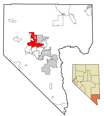
| Ìjúwe | This map shows the incorporated areas in Clark County, Nevada. Las Vegas is highlighted in red. I created it in using data from the following files: Census 2000 Block Map - Clark County (PDF) and Southern Nevada Public Lands Management Act Map (PDF) |
| Ọjọ́ọdún | |
| Orísun | My own work, based on government information. Though I strove to be as accurate in the detail as possible, the information shown is not guaranteed to be completely accurate. |
| Olùdá | Ixnayonthetimmay |
| Ìyọ̀nda (Ìtúnlò fáìlì yìí) |
Public Domain |
| Àwọn àtẹ̀jáde míràn | See Category:Maps of Clark County, Nevada for other versions of this image. |
Ìwé àṣẹ
| Èmi gangan, tó jẹ́ pé èmi ni mo ni ẹ̀tọ́àwòkọ iṣẹ́ yìí, jọ̀wọ́ ìṣẹ́ yìí sínú ìgboro. Èyí kan gbogbo ayé. In some countries this may not be legally possible; if so: I grant anyone the right to use this work for any purpose, without any conditions, unless such conditions are required by law. |
Ìtàn fáìlì
Ẹ kan kliki lórí ọjọ́ọdún/àkókò kan láti wo fáìlì ọ̀ún bó ṣe hàn ní àkókò na.
| Ọjọ́ọdún/Àkókò | Àwòrán kékeré | Àwọn ìwọ̀n | Oníṣe | Àríwí | |
|---|---|---|---|---|---|
| lọ́wọ́ | 01:09, 18 Oṣù Keje 2007 | | 700 × 780 (139 KB) | Ixnayonthetimmay | == Summary == {{Information |Description=This map shows the incorporated areas in Clark County, Nevada. Las Vegas is highlighted in red. I created it in [[en:Inksca |
Ìlò fáìlì
Ojúewé kan yìí únlo fáìlì yí:
Ìlò fáìlì káàkiri
Àwọn wiki míràn wọ̀nyí lo fáìlì yìí:
- Ìlò ní af.wikipedia.org
- Ìlò ní als.wikipedia.org
- Ìlò ní ang.wikipedia.org
- Ìlò ní arz.wikipedia.org
- Ìlò ní ast.wikipedia.org
- Ìlò ní azb.wikipedia.org
- Ìlò ní bn.wikipedia.org
- Ìlò ní br.wikipedia.org
- Ìlò ní bs.wikipedia.org
- Ìlò ní ca.wikipedia.org
- Ìlò ní ceb.wikipedia.org
- Ìlò ní cy.wikipedia.org
- Ìlò ní de.wikipedia.org
- Ìlò ní el.wikipedia.org
- Ìlò ní en.wikipedia.org
- Ìlò ní es.wikipedia.org
- Ìlò ní eu.wikipedia.org
- Ìlò ní fa.wikipedia.org
- Ìlò ní fi.wikipedia.org
- Ìlò ní fi.wiktionary.org
- Ìlò ní fr.wikipedia.org
- Ìlò ní fy.wikipedia.org
- Ìlò ní ga.wikipedia.org
- Ìlò ní gd.wikipedia.org
- Ìlò ní gl.wikipedia.org
- Ìlò ní hr.wikipedia.org
- Ìlò ní ht.wikipedia.org
- Ìlò ní hu.wikipedia.org
- Ìlò ní ia.wikipedia.org
- Ìlò ní id.wikipedia.org
- Ìlò ní ilo.wikipedia.org
- Ìlò ní it.wikipedia.org
- Ìlò ní ja.wikipedia.org
- Ìlò ní jv.wikipedia.org
- Ìlò ní kaa.wikipedia.org
- Ìlò ní ko.wikipedia.org
- Ìlò ní kw.wikipedia.org
- Ìlò ní la.wikipedia.org
- Ìlò ní lb.wikipedia.org
- Ìlò ní lmo.wikipedia.org
- Ìlò ní mai.wikipedia.org
- Ìlò ní min.wikipedia.org
- Ìlò ní ml.wikipedia.org
- Ìlò ní ms.wikipedia.org
- Ìlò ní my.wikipedia.org
- Ìlò ní ne.wikipedia.org
- Ìlò ní nl.wikipedia.org
- Ìlò ní no.wikipedia.org
- Ìlò ní oc.wikipedia.org
Ìfihàn ìlò míràn púpọ̀ fún fálì yìí.