Fáìlì:Karakalpakstan map.png
Ìtóbi ìkọ́yẹ̀wò yìí: 615 × 600 pixels. Àwọn ìgbéhàn míràn: 246 × 240 pixels | 492 × 480 pixels | 718 × 700 pixels.
Fáìlì àtìbẹ̀rẹ̀ (718 × 700 pixel, ìtóbi faili: 40 KB, irú MIME: image/png)
|
|
Fáìlì yìí wá láti Wikimedia Commons. Àròyé láti ojúewé ìjúwe rẹ̀ níbẹ̀ nìyí nísàlẹ̀. |
Àkótán
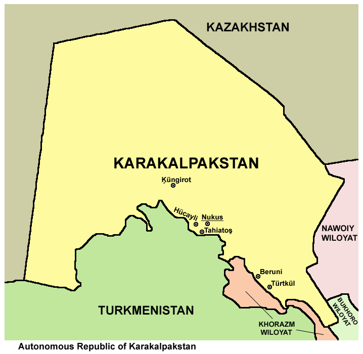
| Ìjúwe |
English: Map of Karakalpakstan. |
| Ọjọ́ọdún | |
| Orísun | Iṣẹ́ onítọ̀hún |
| Olùdá | PANONIAN |
| Àwọn àtẹ̀jáde míràn |
|

Ìwé àṣẹ
Èmi gangan, tó jẹ́ pé èmi ni mo ni ẹ̀tọ́àwòkọ iṣẹ́ yìí, fara mọ́ ọ láti tẹ̀ẹ́jáde lábẹ́ ìwé-àṣẹ ìsàlẹ̀ yìí:
| This file is made available under the Creative Commons CC0 1.0 Universal Public Domain Dedication. | |
| The person who associated a work with this deed has dedicated the work to the public domain by waiving all of their rights to the work worldwide under copyright law, including all related and neighboring rights, to the extent allowed by law. You can copy, modify, distribute and perform the work, even for commercial purposes, all without asking permission.
|
Ìtàn fáìlì
Ẹ kan kliki lórí ọjọ́ọdún/àkókò kan láti wo fáìlì ọ̀ún bó ṣe hàn ní àkókò na.
| Ọjọ́ọdún/Àkókò | Àwòrán kékeré | Àwọn ìwọ̀n | Oníṣe | Àríwí | |
|---|---|---|---|---|---|
| lọ́wọ́ | 10:51, 14 Oṣù Kàrún 2013 | | 718 × 700 (40 KB) | PANONIAN | {{Information |Description ={{en|1=Map of Karakalpakstan.}} |Source ={{own}} |Author =PANONIAN |Date =2013 |Permission = |other_versions = }} |
Ìlò fáìlì
Ojúewé kan yìí únlo fáìlì yí:
Ìlò fáìlì káàkiri
Àwọn wiki míràn wọ̀nyí lo fáìlì yìí:
- Ìlò ní af.wikipedia.org
- Ìlò ní ar.wikipedia.org
- Ìlò ní ast.wikipedia.org
- Ìlò ní az.wikipedia.org
- Ìlò ní ba.wikipedia.org
- Ìlò ní bcl.wikipedia.org
- Ìlò ní be.wikipedia.org
- Ìlò ní br.wikipedia.org
- Ìlò ní bs.wikipedia.org
- Ìlò ní ca.wikipedia.org
- Ìlò ní ceb.wikipedia.org
- Ìlò ní ce.wikipedia.org
- Ìlò ní cs.wikipedia.org
- Ìlò ní cy.wikipedia.org
- Ìlò ní de.wikipedia.org
- Ìlò ní diq.wikipedia.org
- Ìlò ní el.wikipedia.org
- Ìlò ní en.wikipedia.org
- Ìlò ní eo.wikipedia.org
- Ìlò ní es.wikipedia.org
- Ìlò ní eu.wikipedia.org
- Ìlò ní fa.wikipedia.org
- Ìlò ní fi.wikipedia.org
- Ìlò ní fr.wikipedia.org
- Ìlò ní gl.wikipedia.org
- Ìlò ní he.wikipedia.org
- Ìlò ní hi.wikipedia.org
- Ìlò ní hu.wikipedia.org
- Ìlò ní incubator.wikimedia.org
- Ìlò ní it.wikipedia.org
- Ìlò ní ja.wikipedia.org
- Ìlò ní kaa.wikipedia.org
- Ìlò ní ka.wikipedia.org
- Ìlò ní kk.wikipedia.org
- Ìlò ní ky.wikipedia.org
- Ìlò ní mn.wikipedia.org
- Ìlò ní mr.wikipedia.org
- Ìlò ní ms.wikipedia.org
- Ìlò ní mzn.wikipedia.org
- Ìlò ní no.wikipedia.org
- Ìlò ní pa.wikipedia.org
- Ìlò ní pl.wikipedia.org
- Ìlò ní pnb.wikipedia.org
Ìfihàn ìlò míràn púpọ̀ fún fálì yìí.