Fáìlì:131Etendue de l'Empire Français.png
Ìtóbi ìkọ́yẹ̀wò yìí: 800 × 406 pixels. Àwọn ìgbéhàn míràn: 320 × 162 pixels | 640 × 325 pixels | 1,420 × 720 pixels.
Fáìlì àtìbẹ̀rẹ̀ (1,420 × 720 pixel, ìtóbi faili: 95 KB, irú MIME: image/png)
|
|
Fáìlì yìí wá láti Wikimedia Commons. Àròyé láti ojúewé ìjúwe rẹ̀ níbẹ̀ nìyí nísàlẹ̀. |
Àkótán
| Ìjúwe |
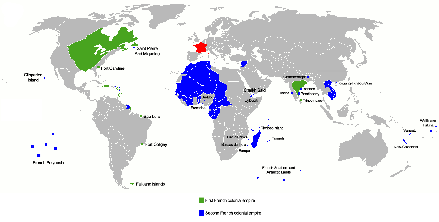
Français : :En vert le 1er empire colonial de 1546 à 1763
Deutsch: :Grün: 1. Kolonialreich von 1546 bis 1763
English: :Green: 1st colonial empire: 1546 to 1763
|
| Ọjọ́ọdún | |
| Orísun | Iṣẹ́ onítọ̀hún |
| Olùdá | Gd21091993 |
| Àwọn àtẹ̀jáde míràn | العربيَّة |

|
File:131Etendue de l'Empire Français.svg is a vector version of this file. It should be used in place of this PNG file when not inferior.
File:131Etendue de l'Empire Français.png → File:131Etendue de l'Empire Français.svg
For more information, see Help:SVG. |
 |
Ìwé àṣẹ
| Èmi gangan, tó jẹ́ pé èmi ni mo ni ẹ̀tọ́àwòkọ iṣẹ́ yìí, jọ̀wọ́ ìṣẹ́ yìí sínú ìgboro. Èyí kan gbogbo ayé. In some countries this may not be legally possible; if so: I grant anyone the right to use this work for any purpose, without any conditions, unless such conditions are required by law. |
Ìtàn fáìlì
Ẹ kan kliki lórí ọjọ́ọdún/àkókò kan láti wo fáìlì ọ̀ún bó ṣe hàn ní àkókò na.
| Ọjọ́ọdún/Àkókò | Àwòrán kékeré | Àwọn ìwọ̀n | Oníṣe | Àríwí | |
|---|---|---|---|---|---|
| lọ́wọ́ | 22:04, 1 Oṣù Kejì 2019 | | 1,420 × 720 (95 KB) | Rzzgn | Correcting uncertainty |
| 10:16, 20 Oṣù Kejìlá 2018 |  | 1,420 × 720 (96 KB) | Rzzgn | == Summary == {{Information |Description={{fr|1=Etendu maximal des possesions Françaises En bleu Claire le 1er Empire de 1546 à 1763 En bleu Foncé le 2eme Empire de 1763 à 1962}} |Source={{own}} |Author=Rzzgn |Date=12/20/2018 |Permission= |other_versions= }} | |
| 10:07, 20 Oṣù Kejìlá 2018 |  | 1,420 × 720 (96 KB) | Rzzgn | {{Information |Description=Etendue_de_l'Empire_Français |Source=own work |Date=2018.12.20 |Author=Rzzgn |Permission= |other_versions= }} | |
| 09:56, 20 Oṣù Kejìlá 2018 |  | 1,425 × 720 (98 KB) | Rzzgn | Reverted to version as of 07:00, 20 December 2018 (UTC) | |
| 07:12, 20 Oṣù Kejìlá 2018 |  | 1,425 × 720 (96 KB) | Rzzgn | Correcting uncertainty | |
| 07:00, 20 Oṣù Kejìlá 2018 |  | 1,425 × 720 (98 KB) | Rzzgn | Correcting uncertainty | |
| 22:23, 4 Oṣù Kẹ̀wá 2014 |  | 1,425 × 720 (77 KB) | Leftcry | Fix accuracy | |
| 01:43, 15 Oṣù Kẹta 2012 |  | 1,425 × 720 (77 KB) | Shid0x02 | Upload errors | |
| 01:39, 15 Oṣù Kẹta 2012 |  | 1,425 × 720 (77 KB) | Shid0x02 | Upload error at the last revision. Changes are the one i listed before. | |
| 01:35, 15 Oṣù Kẹta 2012 |  | 1,425 × 720 (77 KB) | Shid0x02 | Made the map much more clean,more detailed,added name of small enclaves or ''comptoirs''. Green : First french colonial empire Blue : Second french colonial empire Hatched : Under french influence (officially recognized by the concerned country) All ... |
Ìlò fáìlì
Ojúewé kan yìí únlo fáìlì yí:
Ìlò fáìlì káàkiri
Àwọn wiki míràn wọ̀nyí lo fáìlì yìí:
- Ìlò ní ar.wikipedia.org
- Ìlò ní azb.wikipedia.org
- Ìlò ní az.wikipedia.org
- Ìlò ní ba.wikipedia.org
- Ìlò ní be.wikipedia.org
- Ìlò ní bg.wikipedia.org
- Ìlò ní bn.wikipedia.org
- Ìlò ní ce.wikipedia.org
- Ìlò ní da.wikipedia.org
- Ìlò ní de.wikipedia.org
- Ìlò ní el.wikipedia.org
- Ìlò ní en.wikipedia.org
- Ìlò ní es.wikipedia.org
- Ìlò ní fa.wikipedia.org
- Ìlò ní fr.wikipedia.org
- Ìlò ní ha.wikipedia.org
- Ìlò ní he.wikipedia.org
- Ìlò ní hi.wikipedia.org
Ìfihàn ìlò míràn púpọ̀ fún fálì yìí.