Fáìlì:African continent-en.svg

Size of this PNG preview of this SVG file: 635 × 600 pixels. Àwọn ìgbéhàn míràn: 254 × 240 pixels | 508 × 480 pixels | 813 × 768 pixels | 1,084 × 1,024 pixels | 2,169 × 2,048 pixels | 1,525 × 1,440 pixels.
Fáìlì àtìbẹ̀rẹ̀ (faili SVG, pẹ̀lú 1,525 × 1,440 pixels, ìtòbi faili: 752 KB)
|
|
Fáìlì yìí wá láti Wikimedia Commons. Àròyé láti ojúewé ìjúwe rẹ̀ níbẹ̀ nìyí nísàlẹ̀. |
| Ìjúwe |
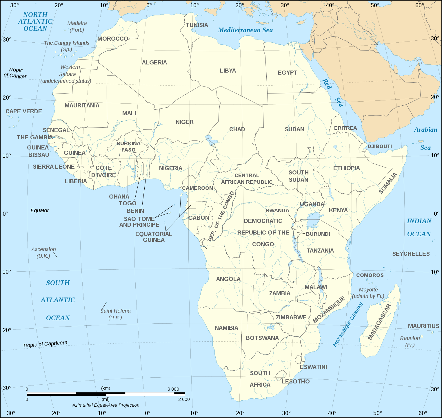
English: Map of the African continent as in 2011-07.
Français : Carte en anglais du continent africain tel qu'en 07/2011.
Lambert azimutal equal-area projection, WGS84 datum, standard meridian: 15°E, standard parallel: 0°Scale: 1:15,000,000 (accuracy: 3,75 km) |
||
| Ọjọ́ọdún | (UTC), updated 2011-07 | ||
| Orísun | |||
| Olùdá |
|
||
| Àwọn àtẹ̀jáde míràn |
Derivative works of this file:
[]
Map close to Africa map political-fr.svg, but with some changes on the islands administrated by European countries and the Sinai peninsula |
||
| SVG genesis |
|


Èmi gangan, tó jẹ́ pé èmi ni mo ni ẹ̀tọ́àwòkọ iṣẹ́ yìí, fara mọ́ ọ láti tẹ̀ẹ́jáde lábẹ́ ìwé-àṣẹ ìsàlẹ̀ yìí:
Fáìlì yìí wà lábẹ́ ìwé àṣẹ Creative Commons Ìdálórúkọ-Share Alike 2.5 Generic, 2.0 Generic àti 1.0 Generic
- Ẹ ní ààyè:
- láti pín pẹ̀lú ẹlòmíràn – láti ṣàwòkọ, pínkiri àti ṣàgbéká iṣẹ́ náà
- láti túndàpọ̀ – láti mulò mọ́ iṣẹ́ míràn
- Lábẹ́ àwọn àdéhùn wọ̀nyí:
- ìdárúkọ – Ẹ gbọdọ̀ ṣe ọ̀wọ̀ tó yẹ, pèsè ìjápọ̀ sí ìwé-àṣe, kí ẹ sì sọ bóyá ìyípadà wáyé. Ẹ le ṣe èyí lórísi ọ̀nà tó bojúmu, sùgbọ́n tí kò ní dà bii pé oníìwé-àṣe fọwọ́ sí yín tàbí lílò yín.
- share alike – Tó bá ṣe pé ẹ ṣ'àtúndàlú, ṣàyípadà, tàbí ṣ'àgbélé sí iṣẹ́-ọwọ́ náà, ẹ lè ṣe ìgbésíta àfikún yín lábẹ́ ìwé-àṣẹ kannáà tàbí tójọra mọ́ ti àtilẹ̀wa.
Original upload log
This image is a derivative work of the following images:
- Image:Africa_map_blank.svg licensed with Cc-by-sa-2.5,2.0,1.0, Cc-by-sa-2.5,2.0,1.0/en
- 2008-06-27T03:34:58Z Sting 1525x1440 (711453 Bytes) Completely new drawing with known projection
- 2006-05-31T15:28:42Z Sting 1390x1295 (571519 Bytes) Enhanced version : African and Asian continents separated
- 2006-05-31T03:53:32Z Sting 1390x1295 (566642 Bytes) {{Information |Description=Blank vector graphic map of [[:Category:Maps of Africa|Africa]] |Source=Several bitmap-type maps |Date= May 2006 |Author= Eric Gaba ({{U|Sting}}) |Permission=GFDL or CC-BY-SA |other_version
Uploaded with derivativeFX
Ìtàn fáìlì
Ẹ kan kliki lórí ọjọ́ọdún/àkókò kan láti wo fáìlì ọ̀ún bó ṣe hàn ní àkókò na.
| Ọjọ́ọdún/Àkókò | Àwòrán kékeré | Àwọn ìwọ̀n | Oníṣe | Àríwí | |
|---|---|---|---|---|---|
| lọ́wọ́ | 18:21, 6 Oṣù Kejìlá 2020 | | 1,525 × 1,440 (752 KB) | Sting | Swatziland => eSwatini |
| 19:59, 14 Oṣù Keje 2011 |  | 1,525 × 1,440 (752 KB) | Sting | Sudan/South Sudan 2011-07 border update | |
| 16:42, 16 Oṣù Kejìlá 2010 |  | 1,525 × 1,440 (747 KB) | Sting | Spelling correction: Madeira | |
| 20:16, 10 Oṣù Kínní 2009 |  | 1,525 × 1,440 (747 KB) | Sting | Correction Sao Tome | |
| 08:37, 6 Oṣù Kejìlá 2008 |  | 1,525 × 1,440 (750 KB) | Bobarino | {{Information |Description={{en|Map of the African continent.}} {{fr|Carte vierge du continent africain.}} Lambert azimutal equal-area projection, WGS84 datum, standard meridian: 15°E, standard pa |
Ìlò fáìlì
Ojúewé kan yìí únlo fáìlì yí:
Ìlò fáìlì káàkiri
Àwọn wiki míràn wọ̀nyí lo fáìlì yìí:
- Ìlò ní af.wikipedia.org
- Ìlò ní ar.wikipedia.org
- Ìlò ní azb.wikipedia.org
- Ìlò ní az.wiktionary.org
- Ìlò ní de.wikipedia.org
- Ìlò ní en.wikipedia.org
- Ìlò ní fa.wikipedia.org
- Ìlò ní hi.wikipedia.org
- Ìlò ní hu.wikibooks.org
- Ìlò ní id.wikipedia.org
- Ìlò ní ig.wikipedia.org
- Ìlò ní ilo.wikipedia.org
- Ìlò ní ja.wikipedia.org
- Ìlò ní ko.wikipedia.org
- Ìlò ní www.mediawiki.org
- Ìlò ní ml.wikipedia.org
- Ìlò ní mn.wikipedia.org
- Ìlò ní nl.wikipedia.org
- Ìlò ní sd.wikipedia.org
- Ìlò ní simple.wikipedia.org
- Ìlò ní sw.wikipedia.org
- Ìlò ní te.wikipedia.org
- Ìlò ní th.wikipedia.org
- Ìlò ní tr.wikipedia.org
- Ìlò ní uz.wikipedia.org