Fáìlì:England locator map with North East England highlighted.svg

Size of this PNG preview of this SVG file: 494 × 600 pixels. Àwọn ìgbéhàn míràn: 198 × 240 pixels | 395 × 480 pixels | 632 × 768 pixels | 843 × 1,024 pixels | 1,686 × 2,048 pixels | 816 × 991 pixels.
Fáìlì àtìbẹ̀rẹ̀ (faili SVG, pẹ̀lú 816 × 991 pixels, ìtòbi faili: 469 KB)
|
|
Fáìlì yìí wá láti Wikimedia Commons. Àròyé láti ojúewé ìjúwe rẹ̀ níbẹ̀ nìyí nísàlẹ̀. |
| Ìjúwe |
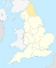
English: Equirectangular projection of England; North East England is highlighted. |
| Ọjọ́ọdún | |
| Orísun | File:England location map.svg |
| Olùdá | |
| Ìyọ̀nda (Ìtúnlò fáìlì yìí) |
Fáìlì yìí wà lábẹ́ ìwé àṣẹ Creative Commons Ìdálórúkọ-Share Alike 3.0 Aláìkówọlé.
|
Ìtàn fáìlì
Ẹ kan kliki lórí ọjọ́ọdún/àkókò kan láti wo fáìlì ọ̀ún bó ṣe hàn ní àkókò na.
| Ọjọ́ọdún/Àkókò | Àwòrán kékeré | Àwọn ìwọ̀n | Oníṣe | Àríwí | |
|---|---|---|---|---|---|
| lọ́wọ́ | 09:34, 8 Oṣù Kẹrin 2010 | | 816 × 991 (469 KB) | Jappalang | {{Information |Description=Equirectangular projection of England; Northumberland is highlighted |Source=File:England location map.svg |Date=2010-04-08 |Author=* File:England location map.svg: Spischot * author: [[User:Jappalang |
Ìlò fáìlì
Àwọn ojúewé 2 wọ̀nyí únlo fáìlì yí:
Ìlò fáìlì káàkiri
Àwọn wiki míràn wọ̀nyí lo fáìlì yìí:
- Ìlò ní am.wikipedia.org
- Ìlò ní ar.wikipedia.org
- Ìlò ní as.wikipedia.org
- Ìlò ní bh.wikipedia.org
- Ìlò ní blk.wikipedia.org
- Ìlò ní bn.wikipedia.org
- Ìlò ní bs.wikipedia.org
- Ìlò ní ca.wikipedia.org
- Ìlò ní cy.wikipedia.org
- Ìlò ní da.wikipedia.org
- Ìlò ní diq.wikipedia.org
- Ìlò ní dty.wikipedia.org
- Ìlò ní dv.wikipedia.org
- Ìlò ní en.wikipedia.org
- Template:Location map+
- Template:Location map~
- Template:Location map+/doc
- Template:Location map+/sandbox
- Template:Location map+/testcases
- Template:Location map~/sandbox
- Template:Location map+/AlternativeMap
- User:Arjunaraoc/sandbox/SampleMap1
- User:Arjunaraoc/sandbox/SampleMap2
- User:Arjunaraoc/sandbox/SampleMap3
- Ìlò ní en.wikibooks.org
- Ìlò ní en.wikiversity.org
- Ìlò ní fa.wikipedia.org
Ìfihàn ìlò míràn púpọ̀ fún fálì yìí.