Fáìlì:Europe-Kosovo.svg

Size of this PNG preview of this SVG file: 713 × 599 pixels. Àwọn ìgbéhàn míràn: 286 × 240 pixels | 571 × 480 pixels | 914 × 768 pixels | 1,218 × 1,024 pixels | 2,437 × 2,048 pixels | 2,182 × 1,834 pixels.
Fáìlì àtìbẹ̀rẹ̀ (faili SVG, pẹ̀lú 2,182 × 1,834 pixels, ìtòbi faili: 2.12 MB)
|
|
Fáìlì yìí wá láti Wikimedia Commons. Àròyé láti ojúewé ìjúwe rẹ̀ níbẹ̀ nìyí nísàlẹ̀. |
Àkótán
| Ìjúwe |
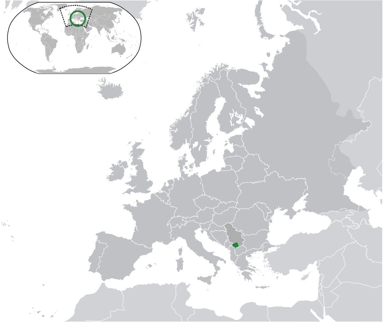
Kosovo, with marked a Serbian claim in another grey (claim) as the other European countries
Is not the same as Europe-Republic of Kosovo.svg, map without Serbian claim on Kosovo, Serbia has the same color as the other European countries Українська: Розташування Косова на мапі Європи |
||
| Ọjọ́ọdún | |||
| Orísun | Iṣẹ́ onítọ̀hún | ||
| Olùdá |
|
||
| Ìyọ̀nda (Ìtúnlò fáìlì yìí) |
|
||
| SVG genesis |

Ìwé àṣẹ
Fáìlì yìí wà lábẹ́ ìwé àṣẹ Creative Commons Ìdálórúkọ-Share Alike 3.0 Aláìkówọlé.
- Ẹ ní ààyè:
- láti pín pẹ̀lú ẹlòmíràn – láti ṣàwòkọ, pínkiri àti ṣàgbéká iṣẹ́ náà
- láti túndàpọ̀ – láti mulò mọ́ iṣẹ́ míràn
- Lábẹ́ àwọn àdéhùn wọ̀nyí:
- ìdárúkọ – Ẹ gbọdọ̀ ṣe ọ̀wọ̀ tó yẹ, pèsè ìjápọ̀ sí ìwé-àṣe, kí ẹ sì sọ bóyá ìyípadà wáyé. Ẹ le ṣe èyí lórísi ọ̀nà tó bojúmu, sùgbọ́n tí kò ní dà bii pé oníìwé-àṣe fọwọ́ sí yín tàbí lílò yín.
- share alike – Tó bá ṣe pé ẹ ṣ'àtúndàlú, ṣàyípadà, tàbí ṣ'àgbélé sí iṣẹ́-ọwọ́ náà, ẹ lè ṣe ìgbésíta àfikún yín lábẹ́ ìwé-àṣẹ kannáà tàbí tójọra mọ́ ti àtilẹ̀wa.
Ìtàn fáìlì
Ẹ kan kliki lórí ọjọ́ọdún/àkókò kan láti wo fáìlì ọ̀ún bó ṣe hàn ní àkókò na.
| Ọjọ́ọdún/Àkókò | Àwòrán kékeré | Àwọn ìwọ̀n | Oníṣe | Àríwí | |
|---|---|---|---|---|---|
| lọ́wọ́ | 13:51, 17 Oṣù Kejìlá 2023 | | 2,182 × 1,834 (2.12 MB) | Iktsokh | Cyprus geographically in Asia |
| 19:11, 12 Oṣù Kejìlá 2020 |  | 2,182 × 1,834 (2.12 MB) | Ahmet Q. | Reverted to version as of 22:34, 11 July 2020 (UTC) | |
| 18:53, 27 Oṣù Kẹ̀wá 2020 |  | 2,182 × 1,834 (2.13 MB) | Savasampion | bigger map | |
| 22:34, 11 Oṣù Keje 2020 |  | 2,182 × 1,834 (2.12 MB) | De728631 | Added South Sudan to World map | |
| 11:12, 6 Oṣù Kẹjọ 2014 |  | 2,045 × 1,720 (2.64 MB) | KronosLine | Reverted to version as of 03:44, 2 July 2013 | |
| 15:58, 30 Oṣù Kàrún 2014 |  | 2,045 × 1,720 (2.7 MB) | Rfc1394 | Add concentric circles around country to make it easier to see when thumbnails of this image are used | |
| 03:44, 2 Oṣù Keje 2013 |  | 2,045 × 1,720 (2.64 MB) | Chipmunkdavis | Reverted to version as of 11:53, 6 August 2012 Serbia is noted here due to the claim | |
| 08:17, 1 Oṣù Keje 2013 |  | 2,045 × 1,720 (2.7 MB) | Klodde | Same color | |
| 11:53, 6 Oṣù Kẹjọ 2012 |  | 2,045 × 1,720 (2.64 MB) | The Emirr | Update. | |
| 16:30, 16 Oṣù Kẹfà 2010 |  | 2,045 × 1,720 (2.7 MB) | The Emirr | {{Information |Description={{en|1={{Europe-SVG-en|Kosovo}}}} |Source={{own}} |Author={{click|image=TheEmirr-Logo.png|link=User:The Emirr|width=60px|height=60px}} |Date=2010-06-16 |Permission={{GFDL}} |other_versions= }} Category:Maps of Kosovo [[Cate |
Ìlò fáìlì
Àwọn ojúewé 2 wọ̀nyí únlo fáìlì yí:
Ìlò fáìlì káàkiri
Àwọn wiki míràn wọ̀nyí lo fáìlì yìí:
- Ìlò ní af.wikipedia.org
- Ìlò ní az.wikipedia.org
- Ìlò ní bn.wikipedia.org
- Ìlò ní ca.wikipedia.org
- Ìlò ní cs.wikipedia.org
- Ìlò ní en.wikipedia.org
- Ìlò ní es.wikipedia.org
- Ìlò ní fa.wikipedia.org
- Ìlò ní hi.wikipedia.org
- Ìlò ní it.wikipedia.org
- Ìlò ní km.wikipedia.org
- Ìlò ní mk.wikipedia.org
- Ìlò ní mn.wikipedia.org
- Ìlò ní my.wikipedia.org
- Ìlò ní no.wikipedia.org
- Ìlò ní pnb.wikipedia.org
- Ìlò ní pt.wikipedia.org
- Ìlò ní rm.wikipedia.org
- Ìlò ní simple.wikipedia.org
- Ìlò ní sr.wikipedia.org
- Ìlò ní ur.wikipedia.org
- Ìlò ní vec.wikipedia.org
- Ìlò ní zh.wikipedia.org