Fáìlì àtìbẹ̀rẹ̀(faili SVG, pẹ̀lú 1,003 × 825 pixels, ìtòbi faili: 833 KB)

Àkótán

Ìjúwe
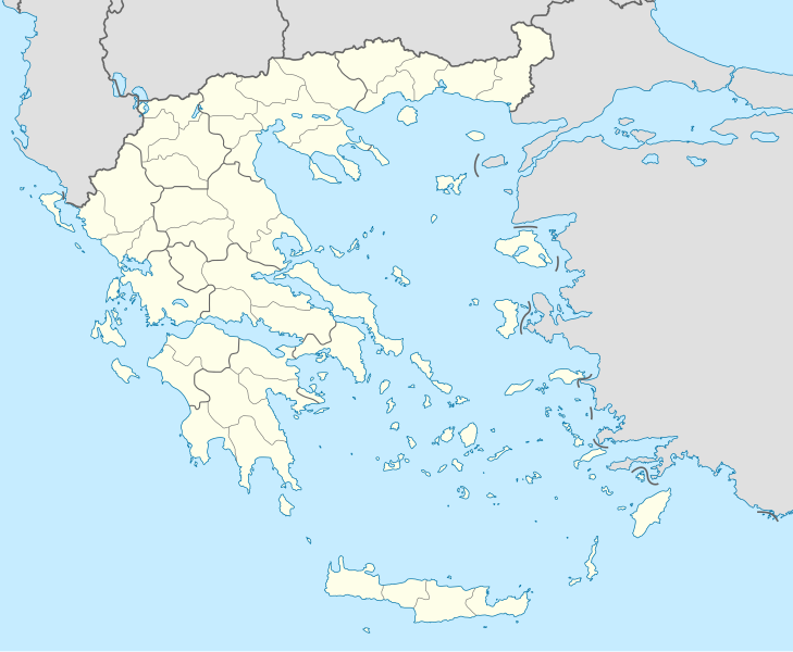
Deutsch: Positionskarte von Griechenland

Quadratische Plattkarte, N-S-Streckung 120 %. Geographische Begrenzung der Karte:

  • N: 42.0° N
  • S: 34.6° N
  • W: 19.1° O
  • O: 29.9° O
English: Location map of Greece

Equirectangular projection, N/S stretching 120 %. Geographic limits of the map:

  • N: 42.0° N
  • S: 34.6° N
  • W: 19.1° E
  • E: 29.9° E
Ọjọ́ọdún
Orísun Iṣẹ́ onítọ̀hún (Original text: own work, using United States National Imagery and Mapping Agency data)
Olùdá Lencer
Àwọn àtẹ̀jáde míràn

Derivative works of this file:

SVG genesis
InfoField
 
The SVG code is valid.
 
This map was created with Inkscape.
Kartenwerkstatt
This SVG map has been made or improved in the German Kartenwerkstatt (Map Lab). You can propose maps to improve as well.

Ìwé àṣẹ

Lencer, tó ni ẹ̀tọ́àwòkọ iṣẹ́ yìí, fara mọ́ ọ láti tẹ̀ẹ́jáde lábẹ́ àwọn ìwé-àṣẹ ìsàlẹ̀ yìí:
GNU head Ìyọ̀nda wà láti ṣe àwòkọ, láti pínkàkiri àti/tàbí ṣ'àtúnse ìwé yìí l'ábẹ́ àwọn ọ̀rọ̀ àdéhùn GNU Free Documentation License, Version 1.2 tàbí ìtẹ̀jáde ọjọ́ọwájú lát'ọwọ́ Free Software Foundation; láìsí àwọn Ẹsẹ Aláìyàtọ̀, láìsí àwọn Ọ̀rọ̀-ìwé Níwájú, àti láìsí Ọ̀rọ̀-ìwé Lẹ́yìn. Àwòkọ ìwé àṣẹ náà jẹ́ sísopọ̀ mọ́ abala tí àkọlé rẹ̀ jẹ́ GNU Free Documentation License.
w:en:Creative Commons
ìdárúkọ share alike
Fáìlì yìí wà lábẹ́ ìwé àṣẹ Creative Commons Ìdálórúkọ-Share Alike 3.0 Aláìkówọlé.
Ìdálórúkọ: Lencer
Ẹ ní ààyè:
  • láti pín pẹ̀lú ẹlòmíràn – láti ṣàwòkọ, pínkiri àti ṣàgbéká iṣẹ́ náà
  • láti túndàpọ̀ – láti mulò mọ́ iṣẹ́ míràn
Lábẹ́ àwọn àdéhùn wọ̀nyí:
  • ìdárúkọ – Ẹ gbọdọ̀ ṣe ọ̀wọ̀ tó yẹ, pèsè ìjápọ̀ sí ìwé-àṣe, kí ẹ sì sọ bóyá ìyípadà wáyé. Ẹ le ṣe èyí lórísi ọ̀nà tó bojúmu, sùgbọ́n tí kò ní dà bii pé oníìwé-àṣe fọwọ́ sí yín tàbí lílò yín.
  • share alike – Tó bá ṣe pé ẹ ṣ'àtúndàlú, ṣàyípadà, tàbí ṣ'àgbélé sí iṣẹ́-ọwọ́ náà, ẹ lè ṣe ìgbésíta àfikún yín lábẹ́ ìwé-àṣẹ kannáà tàbí tójọra mọ́ ti àtilẹ̀wa.
Ẹ le ṣàmúyàn ìwé-àṣẹ tí ó wù yín.

akole

Ṣafikun alaye ila kan ti ohun ti faili yii duro
Location map of Greece

Awọn nkan ṣe afihan ninu faili yii

depicts Èdè Gẹ̀ẹ́sì

Tilos Èdè Gẹ̀ẹ́sì

Dodecanese Èdè Gẹ̀ẹ́sì

Diẹ ninu awọn iye lai a Wikidata ohun kan

author name string Èdè Gẹ̀ẹ́sì: Lencer
Wikimedia username Èdè Gẹ̀ẹ́sì: Lencer

copyright status Èdè Gẹ̀ẹ́sì

copyrighted Èdè Gẹ̀ẹ́sì

source of file Èdè Gẹ̀ẹ́sì

original creation by uploader Èdè Gẹ̀ẹ́sì

23 Oṣù Keje 2008

MIME type Èdè Gẹ̀ẹ́sì

image/svg+xml

Ìtàn fáìlì

Ẹ kan kliki lórí ọjọ́ọdún/àkókò kan láti wo fáìlì ọ̀ún bó ṣe hàn ní àkókò na.

Ọjọ́ọdún/ÀkókòÀwòrán kékeréÀwọn ìwọ̀nOníṣeÀríwí
lọ́wọ́01:13, 10 Oṣù Kejìlá 2015Àwòrán kékeré fún ní 01:13, 10 Oṣù Kejìlá 20151,003 × 825 (833 KB)SilentResidentReverted to version as of 16:28, 11 September 2008 (UTC) The Prefectures became Regional Administrative Units with the same borders
22:33, 18 Oṣù Kejìlá 2010Àwòrán kékeré fún ní 22:33, 18 Oṣù Kejìlá 20101,003 × 825 (673 KB)PitichinaccioPrefecture borders removed. The prefectures of Greece were suppressed in 2010. Präfekturgrenzen entfernt. Die griechischen Präfekturen wurde 2010 abgeschafft.
16:28, 11 Oṣù Kẹ̀sán 2008Àwòrán kékeré fún ní 16:28, 11 Oṣù Kẹ̀sán 20081,003 × 825 (833 KB)Lencer{{Information |Description= |Source= |Date= |Author= |Permission= |other_versions= }}
12:13, 16 Oṣù Kẹjọ 2008Àwòrán kékeré fún ní 12:13, 16 Oṣù Kẹjọ 20081,003 × 825 (818 KB)Lencer{{Information |Description= |Source= |Date= |Author= |Permission= |other_versions= }}
18:26, 23 Oṣù Keje 2008Àwòrán kékeré fún ní 18:26, 23 Oṣù Keje 2008869 × 715 (823 KB)Lencer{{Information |Description= |Source= |Date= |Author= |Permission= |other_versions= }}
18:11, 23 Oṣù Keje 2008Àwòrán kékeré fún ní 18:11, 23 Oṣù Keje 2008869 × 715 (823 KB)Lencer{{Information |Description= {{de|Positionskarte von Griechenland}} Quadratische Plattkarte, N-S-Streckung 120 %. Geographische Begrenzung der Karte: * N: 42.0° N * S: 34.6° N * W: 19.1° O * O: 29.9° O {{en|Location map of

Àwọn ojúewé 4 wọ̀nyí únlo fáìlì yí:

Ìlò fáìlì káàkiri

Metadata