Fáìlì:LocationCentralMiddleAfrica.png
Kò sí ìgbéhàn gíga jù báun lọ.
LocationCentralMiddleAfrica.png (360 × 392 pixel, ìtóbi faili: 11 KB, irú MIME: image/png)
|
|
Fáìlì yìí wá láti Wikimedia Commons. Àròyé láti ojúewé ìjúwe rẹ̀ níbẹ̀ nìyí nísàlẹ̀. |
Àkótán
| Ìjúwe |
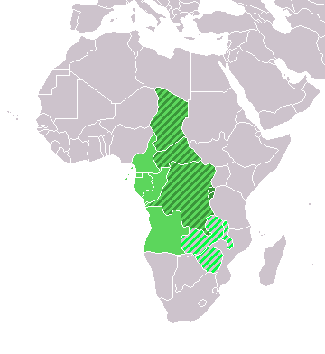
Map: Africa – Central/Middle Africa
|
| Ọjọ́ọdún | 4 Oṣù Kejì 2006 (original upload date) |
| Orísun | No machine-readable source provided. Own work assumed (based on copyright claims). |
| Olùdá | No machine-readable author provided. E Pluribus Anthony~commonswiki assumed (based on copyright claims). |
Ìwé àṣẹ
| Èmi gangan, tó jẹ́ pé èmi ni mo ni ẹ̀tọ́àwòkọ iṣẹ́ yìí, jọ̀wọ́ ìṣẹ́ yìí sínú ìgboro. Èyí kan gbogbo ayé. In some countries this may not be legally possible; if so: I grant anyone the right to use this work for any purpose, without any conditions, unless such conditions are required by law. |
Ìtàn fáìlì
Ẹ kan kliki lórí ọjọ́ọdún/àkókò kan láti wo fáìlì ọ̀ún bó ṣe hàn ní àkókò na.
| Ọjọ́ọdún/Àkókò | Àwòrán kékeré | Àwọn ìwọ̀n | Oníṣe | Àríwí | |
|---|---|---|---|---|---|
| lọ́wọ́ | 18:13, 17 Oṣù Kẹta 2018 | | 360 × 392 (11 KB) | Maphobbyist | Upload |
| 21:01, 9 Oṣù Keje 2011 |  | 360 × 392 (14 KB) | Maphobbyist | South Sudan has become independent on July 9, 2011. Sudan and South Sudan are shown with the new international border between them. | |
| 08:35, 11 Oṣù Kejìlá 2007 |  | 360 × 392 (14 KB) | Hoshie | added Cabinda and Montenegro | |
| 14:04, 30 Oṣù Kejìlá 2006 |  | 360 × 392 (9 KB) | Henrygb~commonswiki | Reverted to earlier revision | |
| 06:01, 1 Oṣù Kẹrin 2006 |  | 360 × 392 (14 KB) | Aris Katsaris | cleaner map -- no need to include defunct federation which confuses the map's purpose. | |
| 17:40, 4 Oṣù Kejì 2006 |  | 360 × 392 (9 KB) | E Pluribus Anthony~commonswiki | Map: Central/Middle Africa (location) |
Ìlò fáìlì
Ojúewé kan yìí únlo fáìlì yí:
Ìlò fáìlì káàkiri
Àwọn wiki míràn wọ̀nyí lo fáìlì yìí:
- Ìlò ní ace.wikipedia.org
- Ìlò ní af.wikipedia.org
- Ìlò ní als.wikipedia.org
- Ìlò ní am.wikipedia.org
- Ìlò ní ar.wikipedia.org
- ليبيا
- جيبوتي
- موريتانيا
- تونس
- السودان
- الصحراء الغربية
- أنغولا
- أوغندا
- إسبانيا
- تشاد
- النيجر
- مالي
- السنغال
- غامبيا
- غينيا بيساو
- غينيا
- سيراليون
- ليبيريا
- غانا
- توغو
- بنين
- بوركينا فاسو
- الصومال
- كينيا
- تنزانيا
- الغابون
- زامبيا
- موزمبيق
- زيمبابوي
- البرتغال
- الكاميرون
- جمهورية الكونغو الديمقراطية
- بوتسوانا
- جنوب إفريقيا
- جمهورية إفريقيا الوسطى
- جمهورية الكونغو
- سيشل
- ناميبيا
- مدغشقر
- ليسوتو
- موريشيوس
- نهر النيل
Ìfihàn ìlò míràn púpọ̀ fún fálì yìí.