Fáìlì:LocationSaint-Martin.PNG
Kò sí ìgbéhàn gíga jù báun lọ.
LocationSaint-Martin.PNG (182 × 115 pixel, ìtóbi faili: 6 KB, irú MIME: image/png)
|
|
Fáìlì yìí wá láti Wikimedia Commons. Àròyé láti ojúewé ìjúwe rẹ̀ níbẹ̀ nìyí nísàlẹ̀. |
Àkótán
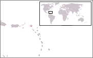
| Ìjúwe | Location map for Saint-Martin. |
| Ọjọ́ọdún | 28 Oṣù Kejì 2007 (original upload date) |
| Orísun | No machine-readable source provided. Own work assumed (based on copyright claims). |
| Olùdá | No machine-readable author provided. Rosss assumed (based on copyright claims). |
Ìwé àṣẹ
| Èmi gangan, tó jẹ́ pé èmi ni mo ni ẹ̀tọ́àwòkọ iṣẹ́ yìí, jọ̀wọ́ ìṣẹ́ yìí sínú ìgboro. Èyí kan gbogbo ayé. In some countries this may not be legally possible; if so: I grant anyone the right to use this work for any purpose, without any conditions, unless such conditions are required by law. |
Ìtàn fáìlì
Ẹ kan kliki lórí ọjọ́ọdún/àkókò kan láti wo fáìlì ọ̀ún bó ṣe hàn ní àkókò na.
| Ọjọ́ọdún/Àkókò | Àwòrán kékeré | Àwọn ìwọ̀n | Oníṣe | Àríwí | |
|---|---|---|---|---|---|
| lọ́wọ́ | 15:49, 19 Oṣù Kọkànlá 2014 | | 182 × 115 (6 KB) | Kontrollstellekundl | cropped and highlighted |
| 23:47, 28 Oṣù Kejì 2007 |  | 250 × 115 (7 KB) | Rosss | ||
| 23:31, 28 Oṣù Kejì 2007 |  | 250 × 115 (7 KB) | Rosss | Location map for Saint-Martin. |
Ìlò fáìlì
Àwọn ojúewé 2 wọ̀nyí únlo fáìlì yí:
Ìlò fáìlì káàkiri
Àwọn wiki míràn wọ̀nyí lo fáìlì yìí:
- Ìlò ní af.wikipedia.org
- Ìlò ní als.wikipedia.org
- Ìlò ní ar.wikipedia.org
- Ìlò ní ba.wikipedia.org
- Ìlò ní be-tarask.wikipedia.org
- Ìlò ní be.wikipedia.org
- Ìlò ní bs.wikipedia.org
- Ìlò ní cs.wikipedia.org
- Ìlò ní da.wikipedia.org
- Ìlò ní de.wikipedia.org
- Ìlò ní el.wikipedia.org
- Ìlò ní el.wiktionary.org
- Ìlò ní en.wikipedia.org
- Ìlò ní es.wikipedia.org
- Ìlò ní es.wikinews.org
- Ìlò ní fa.wikipedia.org
- Ìlò ní fi.wikipedia.org
- Ìlò ní fy.wikipedia.org
- Ìlò ní ia.wikipedia.org
- Ìlò ní id.wikipedia.org
- Ìlò ní incubator.wikimedia.org
- Ìlò ní ja.wikipedia.org
- Ìlò ní li.wikipedia.org
- Ìlò ní lt.wikipedia.org
- Ìlò ní mk.wikipedia.org
- Ìlò ní mr.wikipedia.org
- Ìlò ní ms.wikipedia.org
- Ìlò ní no.wikipedia.org
- Ìlò ní pl.wikipedia.org
- Ìlò ní pl.wiktionary.org
- Ìlò ní pnb.wikipedia.org
- Ìlò ní pt.wikipedia.org
- Ìlò ní ro.wikipedia.org
- Ìlò ní ru.wikipedia.org
- Ìlò ní sh.wikipedia.org
Ìfihàn ìlò míràn púpọ̀ fún fálì yìí.