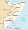
Fáìlì:Somalia&land map.png
Somalia&land_map.png (330 × 355 pixel, ìtóbi faili: 9 KB, irú MIME: image/png)
Ìtàn fáìlì
Ẹ kan kliki lórí ọjọ́ọdún/àkókò kan láti wo fáìlì ọ̀ún bó ṣe hàn ní àkókò na.
| Ọjọ́ọdún/Àkókò | Àwòrán kékeré | Àwọn ìwọ̀n | Oníṣe | Àríwí | |
|---|---|---|---|---|---|
| lọ́wọ́ | 18:14, 20 Oṣù Kẹfà 2020 |  | 330 × 355 (9 KB) | Chipmunkdavis | Reverted to version as of 09:58, 29 November 2005 (UTC) Map already indicates disputes |
| 10:06, 18 Oṣù Kẹfà 2020 |  | 330 × 355 (22 KB) | Meelpringthusss | added disputed area | |
| 09:58, 29 Oṣù Kọkànlá 2005 |  | 330 × 355 (9 KB) | *drew~commonswiki | Map of Somalia, including the boundary of the self-proclaimed Somaliland. Taken from en:Image:So-map-en.png {{PD-USGov-CIA}} |
Ìlò fáìlì
Ojúewé kan yìí únlo fáìlì yí:
Ìlò fáìlì káàkiri
Àwọn wiki míràn wọ̀nyí lo fáìlì yìí:
- Ìlò ní am.wikipedia.org
- Ìlò ní ar.wikipedia.org
- Ìlò ní ast.wikipedia.org
- Ìlò ní bcl.wikipedia.org
- Ìlò ní be-tarask.wikipedia.org
- Ìlò ní bjn.wikipedia.org
- Ìlò ní ca.wikipedia.org
- Ìlò ní ckb.wikipedia.org
- Ìlò ní cs.wikipedia.org
- Ìlò ní da.wikipedia.org
- Ìlò ní de.wikipedia.org
- Ìlò ní de.wikinews.org
- Ìlò ní en.wikipedia.org
- Ìlò ní en.wikinews.org
- Somali tensions rise as Ethiopia sends in troops
- Somali Islamists halt peace talks with government
- Islamist militia driven out of Mogadishu, vow to keep fighting
- Fifteen killed in Somalia bombing
- Violence in Somalia displaces over 27,000
- User:Bawolff/sandbox/Lead-only Main Page/leadList/Violence in Somalia displaces over 27,000
- At least twelve die in Mogadishu attacks
- Ìlò ní eo.wikipedia.org
- Ìlò ní fa.wikipedia.org
- Ìlò ní fy.wikipedia.org
- Ìlò ní he.wikipedia.org
- Ìlò ní hif.wikipedia.org
Ìfihàn ìlò míràn púpọ̀ fún fálì yìí.

