Fáìlì:Tectonic plates Caribbean.png

Fáìlì àtìbẹ̀rẹ̀ (1,024 × 768 pixel, ìtóbi faili: 64 KB, irú MIME: image/png)
|
|
Fáìlì yìí wá láti Wikimedia Commons. Àròyé láti ojúewé ìjúwe rẹ̀ níbẹ̀ nìyí nísàlẹ̀. |
Transferred from en.wikipedia to Commons by Maksim.
| Èmi gangan, tó jẹ́ pé èmi ni mo ni ẹ̀tọ́àwòkọ iṣẹ́ yìí, jọ̀wọ́ ìṣẹ́ yìí sínú ìgboro. Èyí kan gbogbo ayé. In some countries this may not be legally possible; if so: I grant anyone the right to use this work for any purpose, without any conditions, unless such conditions are required by law. |
This work was derived from Image:Tectonic_plates.png, an image in the public domain (PD-USGov-Interior-USGS).
| date/time | username | edit summary |
|---|---|---|
| 17:17, 9 July 2005 | en:User:Gruepig | (public domain (derived from USGS work)) |
| 17:07, 9 July 2005 | en:User:Gruepig |

|
This geology image could be re-created using vector graphics as an SVG file. This has several advantages; see Commons:Media for cleanup for more information. If an SVG form of this image is available, please upload it and afterwards replace this template with
{{vector version available|new image name}}.
It is recommended to name the SVG file “Tectonic plates Caribbean.svg”—then the template Vector version available (or Vva) does not need the new image name parameter. |
- File:Plates tect2 en.svg would be useful as a starting point for a SVG
Original upload log
Legend: (cur) = this is the current file, (del) = delete this old version, (rev) = revert to this old version.
Click on date to download the file or see the image uploaded on that date.
- (del) (cur) 17:07, 9 July 2005 . . en:User:Gruepig Gruepig ( en:User_talk:Gruepig Talk) . . 3000x2250 (1157305 bytes)
Ìtàn fáìlì
Ẹ kan kliki lórí ọjọ́ọdún/àkókò kan láti wo fáìlì ọ̀ún bó ṣe hàn ní àkókò na.
| Ọjọ́ọdún/Àkókò | Àwòrán kékeré | Àwọn ìwọ̀n | Oníṣe | Àríwí | |
|---|---|---|---|---|---|
| lọ́wọ́ | 01:32, 16 Oṣù Kejì 2013 | | 1,024 × 768 (64 KB) | JohnnyMrNinja | reduce size over 3x with color indexing and slightly higher compression |
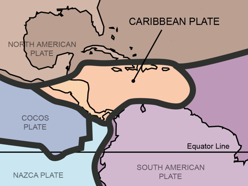
| 20:51, 31 Oṣù Kẹjọ 2011 |  | 1,024 × 768 (211 KB) | AlexCovarrubias | Centered map on the Caribbean Plate. | |
| 16:30, 5 Oṣù Kejì 2006 |  | 3,000 × 2,250 (1.1 MB) | Maksim | La bildo estas kopiita de wikipedia:en. La originala priskribo estas: {{PD-self}} This work was derived from Image:Tectonic_plates.png, an image in the public domain (PD-USGov-Interior-USGS). {| border="1" ! date/time || username || edit summary |---- |
Ìlò fáìlì
Ojúewé kan yìí únlo fáìlì yí:
Ìlò fáìlì káàkiri
Àwọn wiki míràn wọ̀nyí lo fáìlì yìí:
- Ìlò ní ar.wikipedia.org
- Ìlò ní be.wikipedia.org
- Ìlò ní bo.wikipedia.org
- Ìlò ní bs.wikipedia.org
- Ìlò ní ca.wikipedia.org
- Ìlò ní da.wikipedia.org
- Ìlò ní de.wikipedia.org
- Ìlò ní en.wikipedia.org
- Ìlò ní eo.wikipedia.org
- Ìlò ní es.wikipedia.org
- Ìlò ní eu.wikipedia.org
- Ìlò ní fa.wikipedia.org
- Ìlò ní fi.wikipedia.org
- Ìlò ní fr.wikipedia.org
- Ìlò ní fy.wikipedia.org
- Ìlò ní ga.wikipedia.org
- Ìlò ní he.wikipedia.org
- Ìlò ní hi.wikipedia.org
- Ìlò ní hu.wikipedia.org
- Ìlò ní hy.wikipedia.org
- Ìlò ní id.wikipedia.org
- Ìlò ní it.wikipedia.org
- Ìlò ní ja.wikipedia.org
- Ìlò ní ka.wikipedia.org
Ìfihàn ìlò míràn púpọ̀ fún fálì yìí.