Fáìlì:We-map.png

Ìtóbi ìkọ́yẹ̀wò yìí: 275 × 600 pixels. Àwọn ìgbéhàn míràn: 110 × 240 pixels | 326 × 711 pixels.
Fáìlì àtìbẹ̀rẹ̀ (326 × 711 pixel, ìtóbi faili: 22 KB, irú MIME: image/png)
|
|
Fáìlì yìí wá láti Wikimedia Commons. Àròyé láti ojúewé ìjúwe rẹ̀ níbẹ̀ nìyí nísàlẹ̀. |
Àkótán
| Ìjúwe |
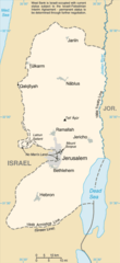
English: Replacement map of the West Bank from CIA Factbook |
| Orísun | The original GIF image source for this map is: archive copy at the Wayback Machine |
| Olùdá | This PNG image was copied from en.wikipedia.org. |
This image is in the public domain because it contains materials that originally came from the United States Central Intelligence Agency's World Factbook.
|
 |
Ìtàn fáìlì
Ẹ kan kliki lórí ọjọ́ọdún/àkókò kan láti wo fáìlì ọ̀ún bó ṣe hàn ní àkókò na.
| Ọjọ́ọdún/Àkókò | Àwòrán kékeré | Àwọn ìwọ̀n | Oníṣe | Àríwí | |
|---|---|---|---|---|---|
| lọ́wọ́ | 13:56, 25 Oṣù Kẹta 2010 | | 326 × 711 (22 KB) | Ras67 | cropped |
| 12:35, 15 Oṣù Kẹ̀sán 2004 |  | 330 × 715 (23 KB) | Robbot | This image was copied from en.wikipedia.org. The original description was: Replacement map of the West Bank from CIA Factbook - public domain en:Image:We-map.png {{PD-USgov}} |
Ìlò fáìlì
Ojúewé kan yìí únlo fáìlì yí:
Ìlò fáìlì káàkiri
Àwọn wiki míràn wọ̀nyí lo fáìlì yìí:
- Ìlò ní af.wikipedia.org
- Ìlò ní als.wikipedia.org
- Ìlò ní ar.wikinews.org
- Ìlò ní ast.wikipedia.org
- Ìlò ní be-tarask.wikipedia.org
- Ìlò ní be.wikipedia.org
- Ìlò ní bg.wikipedia.org
- Ìlò ní br.wikipedia.org
- Ìlò ní bs.wikipedia.org
- Ìlò ní ca.wikipedia.org
- Ìlò ní ce.wikipedia.org
- Ìlò ní cs.wikipedia.org
- Ìlò ní cy.wikipedia.org
- Ìlò ní da.wikipedia.org
- Ìlò ní el.wikipedia.org
- Ìlò ní en.wikipedia.org
- Ìlò ní en.wikinews.org
- Ìlò ní eo.wikipedia.org
- Ìlò ní es.wikipedia.org
- Ìlò ní es.wikinews.org
- Ìlò ní et.wikipedia.org
- Ìlò ní fa.wikipedia.org
- Ìlò ní fi.wikipedia.org
- Ìlò ní fi.wiktionary.org
- Ìlò ní fo.wikipedia.org
- Ìlò ní frr.wikipedia.org
- Ìlò ní fr.wikipedia.org
- Ìlò ní fy.wikipedia.org
- Ìlò ní gd.wikipedia.org
- Ìlò ní gn.wikipedia.org
- Ìlò ní gv.wikipedia.org
- Ìlò ní hr.wikipedia.org
Ìfihàn ìlò míràn púpọ̀ fún fálì yìí.