Kansas

Ìkan lára àwọn ìpínlẹ̀ ní orílé-èdè ìṣọ̀kan Amẹ́ríkà
(Àtúnjúwe láti Ìpínlè Kansas)
State of Kansas
Flag of Kansas State seal of Kansas
Flag Èdìdí
Ìlàjẹ́: The Sunflower State (official);
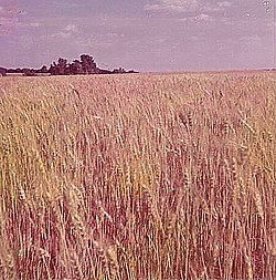
The Wheat State
Motto(s): Ad astra per aspera
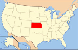
Map of the United States with Kansas highlighted
Èdè oníibiṣẹ́ English[1]
Orúkọaráàlú Kansan
Olúìlú Topeka
Ìlú atóbijùlọ Wichita
Largest metro area Kansas City Metro Area
Àlà  Ipò 15th ní U.S.
 - Total 82,277 sq mi
(213,096 km2)
 - Width 417 miles (645 km)
 - Length 211 miles (340 km)
 - % water 0.56
 - Latitude 37° N to 40° N
 - Longitude 94° 35′ W to 102° 3′ W
Iyeèrò  Ipò 33rd ní U.S.
 - Total 2,818,747 (2009 est.)[2]
2,688,418 (2000)
Density 32.9/sq mi  (12.7/km2)
Ranked 40th in the U.S.
Elevation  
 - Highest point Mount Sunflower[3]
4,039 ft (1,232 m)
 - Mean 2,000 ft  (600 m)
 - Lowest point Verdigris River[3]
679 ft (207 m)
Admission to Union  January 29, 1861 (34th)
Gómìnà Jeff Colyer (R)
Ìgbákejì Gómìnà
Legislature Kansas Legislature
 - Upper house Senate
 - Lower house House of Representatives
U.S. Senators Jerry Moran (R)
Pat Roberts (R)
U.S. House delegation Tim Huelskamp (R)
Lynn Jenkins (R)
Kevin Yoder (D)
Mike Pompeo (R) (list)
Time zones  
 - most of state Central: UTC-6/-5
 - 4 western counties Mountain: UTC-7/-6
Abbreviations KS US-KS
Website kansas.gov
Winter wheat fields in western Kansas awaiting harvest, May 1972

Ipinle Kansas je ikan ninu ipinle awon ipinle adota ni orile-ede Amerika.


  1. "Governor’s Signature Makes English the Official Language of Kansas". Us-english.org. 2007-05-11. Retrieved 2008-08-06. 
  2. "Annual Estimates of the Resident Population for the United States, Regions, States, and Puerto Rico: April 1, 2000 to July 1, 2009". United States Census Bureau. Retrieved 2010-06-05. 
  3. 3.0 3.1 "Elevations and Distances in the United States". U.S Geological Survey. 29 April 2005. Archived from the original on 1 June 2008. Retrieved November 6, 2006.