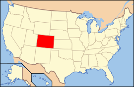
Colorado
Ìkan lára àwọn ìpínlẹ̀ ní orílé-èdè ìṣọ̀kan Amẹ́ríkà
Ipinle Kolorado
| State of Colorado | |||||
| |||||
| Ìlàjẹ́: The Centennial State | |||||
| Motto(s): Nil sine numine (Nothing without providence) | |||||
 | |||||
| Èdè oníibiṣẹ́ | English | ||||
| Orúkọaráàlú | Coloradan[1][2] | ||||
| Olúìlú | Denver | ||||
| Ìlú atóbijùlọ | Denver | ||||
| Largest metro area | Denver-Aurora Metro Area | ||||
| Àlà | Ipò 8th ní U.S. | ||||
| - Total | 104,185 sq mi (269,837 km2) | ||||
| - Width | 280 miles (451 km) | ||||
| - Length | 380 miles (612 km) | ||||
| - % water | 0.36% | ||||
| - Latitude | 37°N to 41°N | ||||
| - Longitude | 102°03'W to 109°03'W | ||||
| Iyeèrò | Ipò 22nd ní U.S. | ||||
| - Total | 4,939,456 (2008 est.)[3] 4,301,261 (2000) | ||||
| - Density | 41.5/sq mi (16.01/km2) Ranked 37th in the U.S. | ||||
| - Median income | $51,022 (10th) | ||||
| Elevation | |||||
| - Highest point | Mount Elbert[4][5] 14,440 ft (4401 m) | ||||
| - Mean | 6,800 ft (2073 m) | ||||
| - Lowest point | Arikaree River[4] 3,315 ft (1010 m) | ||||
| Admission to Union | August 1, 1876 (38th) | ||||
| Gómìnà | John Hickenlooper (D) | ||||
| Ìgbákejì Gómìnà | Barbara O'Brien (D) | ||||
| Legislature | {{{Legislature}}} | ||||
| - Upper house | {{{Upperhouse}}} | ||||
| - Lower house | {{{Lowerhouse}}} | ||||
| U.S. Senators | 2 - Mark Udall (D) 3 - Michael Bennet (D) | ||||
| U.S. House delegation | 5 Democrats, 2 Republicans (list) | ||||
| Time zone | MST=UTC-07, MDT=UTC-06 | ||||
| Abbreviations | CO Colo. US-CO | ||||
| Website | colorado.gov | ||||

|
Àyọkà yìí tàbí apá rẹ̀ únfẹ́ àtúnṣe sí. Ẹ le fẹ̀ jù báyìí lọ tàbí kí ẹ ṣàtúnṣe rẹ̀ lọ́nà tí yíò mu kúnrẹ́rẹ́. Ẹ ran Wikipedia lọ́wọ́ láti fẹ̀ẹ́ jù báyìí lọ. |
Itokasi
àtúnṣe- ↑ Writers Style Guide Archived 2015-02-19 at the Wayback Machine., Colorado State University, accessed January 19, 2009
- ↑ http://www.denverpost.com/opinion/ci_5447358 Coloradoan or Coloradan
- ↑ "Annual Estimates of the Resident Population for the United States, Regions, States, and Puerto Rico: April 1, 2000 to July 1, 2008". United States Census Bureau. Retrieved 2009-02-05.
- ↑ 4.0 4.1 "Elevations and Distances in the United States". U.S. Geological Survey. 2005-04-29. Archived from the original on 2008-06-01. Retrieved 2007-10-19.
- ↑ "National Geodetic Survey data sheet KL0637 for Mount Elbert". National Geodetic Survey. Retrieved 2007-10-19.

