Fáìlì:Komondjari department.png

Ìtóbi ìkọ́yẹ̀wò yìí: 776 × 600 pixels. Àwọn ìgbéhàn míràn: 311 × 240 pixels | 621 × 480 pixels | 994 × 768 pixels | 1,056 × 816 pixels.
Fáìlì àtìbẹ̀rẹ̀ (1,056 × 816 pixel, ìtóbi faili: 39 KB, irú MIME: image/png)
|
|
Fáìlì yìí wá láti Wikimedia Commons. Àròyé láti ojúewé ìjúwe rẹ̀ níbẹ̀ nìyí nísàlẹ̀. |
Àkótán
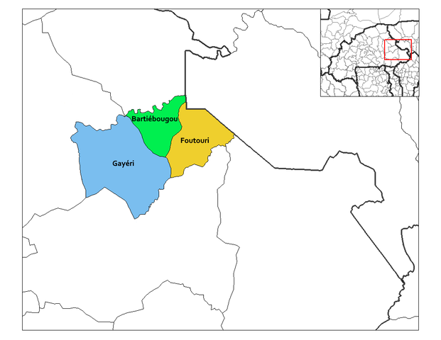
| Ìjúwe | Map of the Komondjari Province (capital : Gayéri department) in Burkina Faso. |
| Ọjọ́ọdún | 11 Oṣù Ẹ̀rẹ̀nà 2007 (original upload date) |
| Orísun | No machine-readable source provided. Own work assumed (based on copyright claims). |
| Olùdá |
No machine-readable author provided. Osiris fancy assumed (based on copyright claims). Created by Rarelibra 03:23, 30 September 2006 (UTC) for public domain use, using MapInfo Professional v8.5 and various mapping resources. This map has been uploaded by Osiris fancy from en.wikipedia.org to enable the Wikimedia Atlas of the World. Original uploader to en.wikipedia.org was Rarelibra. Osiris fancy is not the creator of this map. Licensing information is below. |
Ìwé àṣẹ
| Èmi gangan, tó jẹ́ pé èmi ni mo ni ẹ̀tọ́àwòkọ iṣẹ́ yìí, jọ̀wọ́ ìṣẹ́ yìí sínú ìgboro. Èyí kan gbogbo ayé. In some countries this may not be legally possible; if so: I grant anyone the right to use this work for any purpose, without any conditions, unless such conditions are required by law. |
Ìtàn fáìlì
Ẹ kan kliki lórí ọjọ́ọdún/àkókò kan láti wo fáìlì ọ̀ún bó ṣe hàn ní àkókò na.
| Ọjọ́ọdún/Àkókò | Àwòrán kékeré | Àwọn ìwọ̀n | Oníṣe | Àríwí | |
|---|---|---|---|---|---|
| lọ́wọ́ | 20:54, 25 Oṣù Ọ̀pẹ̀ 2021 | | 1,056 × 816 (39 KB) | Verdy p | actual delimitation of the 3 departements |
| 16:57, 11 Oṣù Ẹ̀rẹ̀nà 2007 |  | 1,056 × 816 (25 KB) | Osiris fancy | This map has been uploaded by Osiris fancy from en.wikipedia.org to enable the Wikimedia Atlas of the World. Original uploader to en.wikipedia.org was Rarelibra. Osiris fancy is not the creator of this map. Licensing information is |
Ìlò fáìlì
Ojúewé kan yìí únlo fáìlì yí:
Ìlò fáìlì káàkiri
Àwọn wiki míràn wọ̀nyí lo fáìlì yìí:
- Ìlò ní cs.wikipedia.org
- Ìlò ní en.wikipedia.org
- Ìlò ní es.wikipedia.org
- Ìlò ní fa.wikipedia.org
- Ìlò ní fr.wikipedia.org
- Ìlò ní ha.wikipedia.org
- Ìlò ní id.wikipedia.org
- Ìlò ní ig.wikipedia.org
- Ìlò ní it.wikipedia.org
- Ìlò ní ja.wikipedia.org
- Ìlò ní ko.wikipedia.org
- Ìlò ní nl.wikipedia.org
- Ìlò ní pt.wikipedia.org
- Ìlò ní ro.wikipedia.org
- Ìlò ní sw.wikipedia.org
- Ìlò ní ts.wikipedia.org
- Ìlò ní tum.wikipedia.org
- Ìlò ní ur.wikipedia.org
- Ìlò ní vi.wikipedia.org
- Ìlò ní www.wikidata.org
- Ìlò ní zh.wikipedia.org
- Ìlò ní zu.wikipedia.org