Fáìlì:Map of South Africa with Vhembe highlighted (2011).svg

Size of this PNG preview of this SVG file: 684 × 599 pixels. Àwọn ìgbéhàn míràn: 274 × 240 pixels | 548 × 480 pixels | 876 × 768 pixels | 1,168 × 1,024 pixels | 2,337 × 2,048 pixels | 809 × 709 pixels.
Fáìlì àtìbẹ̀rẹ̀ (faili SVG, pẹ̀lú 809 × 709 pixels, ìtòbi faili: 482 KB)
|
|
Fáìlì yìí wá láti Wikimedia Commons. Àròyé láti ojúewé ìjúwe rẹ̀ níbẹ̀ nìyí nísàlẹ̀. |
.svg)
Àkótán
| Ìjúwe |
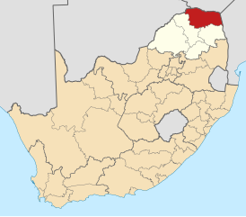
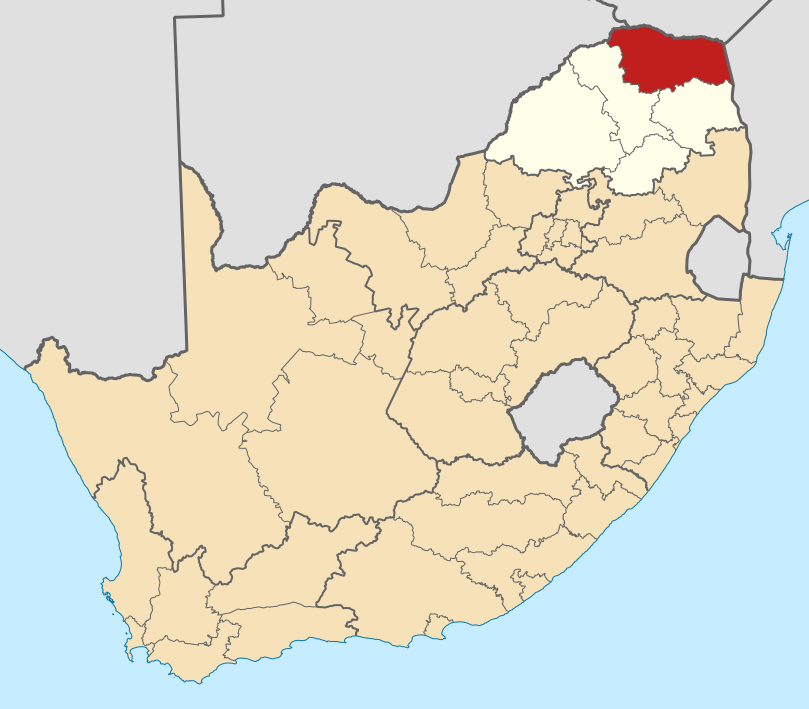
English: Map of district boundaries in South Africa, as they will be after the municipal elections of 18 May 2011, with the Vhembe District Municipality highlighted in red within Limpopo in yellow. |
| Ọjọ́ọdún | |
| Orísun | Iṣẹ́ onítọ̀hún |
| Olùdá | Htonl |
Ìwé àṣẹ
Èmi gangan, tó jẹ́ pé èmi ni mo ni ẹ̀tọ́àwòkọ iṣẹ́ yìí, fara mọ́ ọ láti tẹ̀ẹ́jáde lábẹ́ àwọn ìwé-àṣẹ ìsàlẹ̀ yìí:

|
Ìyọ̀nda wà láti ṣe àwòkọ, láti pínkàkiri àti/tàbí ṣ'àtúnse ìwé yìí l'ábẹ́ àwọn ọ̀rọ̀ àdéhùn GNU Free Documentation License, Version 1.2 tàbí ìtẹ̀jáde ọjọ́ọwájú lát'ọwọ́ Free Software Foundation; láìsí àwọn Ẹsẹ Aláìyàtọ̀, láìsí àwọn Ọ̀rọ̀-ìwé Níwájú, àti láìsí Ọ̀rọ̀-ìwé Lẹ́yìn. Àwòkọ ìwé àṣẹ náà jẹ́ sísopọ̀ mọ́ abala tí àkọlé rẹ̀ jẹ́ GNU Free Documentation License. |
This file is licensed under the Creative Commons Attribution-Share Alike 4.0 International, 3.0 Unported, 2.5 Generic, 2.0 Generic and 1.0 Generic license.
- Ẹ ní ààyè:
- láti pín pẹ̀lú ẹlòmíràn – láti ṣàwòkọ, pínkiri àti ṣàgbéká iṣẹ́ náà
- láti túndàpọ̀ – láti mulò mọ́ iṣẹ́ míràn
- Lábẹ́ àwọn àdéhùn wọ̀nyí:
- ìdárúkọ – Ẹ gbọdọ̀ ṣe ọ̀wọ̀ tó yẹ, pèsè ìjápọ̀ sí ìwé-àṣe, kí ẹ sì sọ bóyá ìyípadà wáyé. Ẹ le ṣe èyí lórísi ọ̀nà tó bojúmu, sùgbọ́n tí kò ní dà bii pé oníìwé-àṣe fọwọ́ sí yín tàbí lílò yín.
- share alike – Tó bá ṣe pé ẹ ṣ'àtúndàlú, ṣàyípadà, tàbí ṣ'àgbélé sí iṣẹ́-ọwọ́ náà, ẹ lè ṣe ìgbésíta àfikún yín lábẹ́ ìwé-àṣẹ kannáà tàbí tójọra mọ́ ti àtilẹ̀wa.
Ẹ le ṣàmúyàn ìwé-àṣẹ tí ó wù yín.
Ìtàn fáìlì
Ẹ kan kliki lórí ọjọ́ọdún/àkókò kan láti wo fáìlì ọ̀ún bó ṣe hàn ní àkókò na.
| Ọjọ́ọdún/Àkókò | Àwòrán kékeré | Àwọn ìwọ̀n | Oníṣe | Àríwí | |
|---|---|---|---|---|---|
| lọ́wọ́ | 00:59, 14 Oṣù Kàrún 2011 | | 809 × 709 (482 KB) | Htonl | == Summary == {{Information |Description ={{en|1=Map of district boundaries in South Africa, as they will be after the municipal elections of 18 May 2011, with the w:Vhembe District Municipality highlig |
Ìlò fáìlì
Ojúewé kan yìí únlo fáìlì yí:
Ìlò fáìlì káàkiri
Àwọn wiki míràn wọ̀nyí lo fáìlì yìí:
- Ìlò ní af.wikipedia.org
- Louis Trichardt, Limpopo
- Musina
- Thohoyandou
- Beitbrug
- Buysdorp
- Tshipise (dorpie)
- Sjabloonbespreking:Suid-Afrikaanse distriksmunisipaliteit navbox
- Olifantshoek, Limpopo
- Waterval, Limpopo
- Valdezia
- Kranspoort
- Laatsgevonden
- Levubu
- Bungeni
- Bandelierkop
- Hlanganani, Limpopo
- Dzanani
- Honingfontein
- Tiyani
- Tshitale
- Tshikota
- Vuwani
- Nyavani
- Shigalo
- Sibasa
- Makwarela
- Makumeke
- Maranzhe
- Lwamondo
- Green Farm, Limpopo
- Duthuni
- Malamulele
- Mutale
- Shakadza
- Malale
- Madimbo
- Mopane
- Basani
- Dopeni
- Dzwerani
- Gaba
- Gandlanani
- Gondeni A
- Hasane
- Hatshisele
- Itsani
- Ha-Lambani
- Jimmy Jones, Limpopo
- Jerome, Limpopo
- Jilongo
Ìfihàn ìlò míràn púpọ̀ fún fálì yìí.
.svg)
.svg)