Fáìlì:Nigeria Topography.png

Ìtóbi ìkọ́yẹ̀wò yìí: 662 × 600 pixels. Àwọn ìgbéhàn míràn: 265 × 240 pixels | 530 × 480 pixels | 848 × 768 pixels | 1,131 × 1,024 pixels | 1,708 × 1,547 pixels.
Fáìlì àtìbẹ̀rẹ̀ (1,708 × 1,547 pixel, ìtóbi faili: 3.03 MB, irú MIME: image/png)
|
|
Fáìlì yìí wá láti Wikimedia Commons. Àròyé láti ojúewé ìjúwe rẹ̀ níbẹ̀ nìyí nísàlẹ̀. |
zamfa gusau
Àkótán
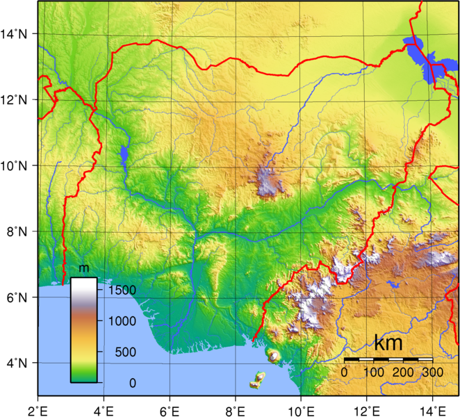
| Ìjúwe | Topographic map of Nigeria. Created with GMT from public domain GLOBE data. |
| Ọjọ́ọdún | |
| Orísun | Iṣẹ́ onítọ̀hún |
| Olùdá | Sadalmelik |
Ìwé àṣẹ
| This work has been released into the public domain by its author, I, Sadalmelik. This applies worldwide. In some countries this may not be legally possible; if so: I, Sadalmelik grants anyone the right to use this work for any purpose, without any conditions, unless such conditions are required by law. |
Ìtàn fáìlì
Ẹ kan kliki lórí ọjọ́ọdún/àkókò kan láti wo fáìlì ọ̀ún bó ṣe hàn ní àkókò na.
| Ọjọ́ọdún/Àkókò | Àwòrán kékeré | Àwọn ìwọ̀n | Oníṣe | Àríwí | |
|---|---|---|---|---|---|
| lọ́wọ́ | 20:44, 29 Oṣù Kẹfà 2007 | | 1,708 × 1,547 (3.03 MB) | Sadalmelik | Better data, better colours |
| 14:32, 22 Oṣù Kẹfà 2007 |  | 1,708 × 1,547 (2.18 MB) | Sadalmelik | {{Information |Description= |Source=self-made |Date= |Author= Sadalmelik }} | |
| 18:50, 16 Oṣù Kẹfà 2007 |  | 1,708 × 1,547 (2.1 MB) | Sadalmelik | {{Information |Description=Topographic map of Nigeria. Created with GMT from public domain GLOBE data. |Source=self-made |Date=June 16, 2007 |Author= Sadalmelik }} Category:Maps of Nigeria Category:Topographic maps of Africa |
Ìlò fáìlì
Ojúewé kan yìí únlo fáìlì yí:
Ìlò fáìlì káàkiri
Àwọn wiki míràn wọ̀nyí lo fáìlì yìí:
- Ìlò ní af.wikipedia.org
- Ìlò ní als.wikipedia.org
- Ìlò ní an.wikipedia.org
- Ìlò ní ar.wikipedia.org
- Ìlò ní avk.wikipedia.org
- Ìlò ní azb.wikipedia.org
- Ìlò ní bg.wikipedia.org
- Ìlò ní bs.wikipedia.org
- Ìlò ní ca.wikipedia.org
- Ìlò ní ceb.wikipedia.org
- Ìlò ní da.wikipedia.org
- Ìlò ní de.wikipedia.org
- Ìlò ní en.wikipedia.org
- Ìlò ní eo.wikipedia.org
- Ìlò ní fa.wikipedia.org
- Ìlò ní fr.wikipedia.org
- Ìlò ní ha.wikipedia.org
- Ìlò ní hu.wikipedia.org
- Ìlò ní hy.wikipedia.org
- Ìlò ní id.wikipedia.org
- Ìlò ní ig.wikipedia.org
- Ìlò ní ka.wikipedia.org
- Ìlò ní no.wikipedia.org
- Ìlò ní oc.wikipedia.org
- Ìlò ní pt.wikipedia.org
- Ìlò ní ru.wikipedia.org
- Ìlò ní sv.wikipedia.org
- Ìlò ní tum.wikipedia.org
- Ìlò ní uk.wikipedia.org
- Ìlò ní vec.wikipedia.org
- Ìlò ní vep.wikipedia.org
- Ìlò ní www.wikidata.org
- Ìlò ní zh.wikipedia.org