Fáìlì:Rajendra territories cl.png
Rajendra_territories_cl.png (650 × 464 pixel, ìtóbi faili: 504 KB, irú MIME: image/png)
|
|
Fáìlì yìí wá láti Wikimedia Commons. Àròyé láti ojúewé ìjúwe rẹ̀ níbẹ̀ nìyí nísàlẹ̀. |

Àkótán
| Ìjúwe |
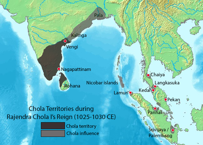
Map showing the extent of the Chola empire during Rajendra Chola I. Source of map: http://www2.demis.nl/mapserver/mapper.asp (mention : "Disclaimer: With this statement DEMIS BV grants you permission to freely copy the PNG images returned by our server and use them for your own purposes, including web pages. We would appreciate a reference to our server but such a reference is not required, nor do we take responsibility for the accuracy or quality of the maps". at http://www2.demis.nl/mapserver/DataSrc.htm) Modified by myself using Adobe Photoshop. Note: This file was imported to Commons by Nicke L on 25 June 2006, then updated based on https://commons.wikimedia.org/wiki/File:Rajendra_map_new.svg and https://en.wikipedia.org/wiki/Talk:Chola_dynasty#Maps by Verosaurus on 27 December 2022. Pegu isn't included in the influence area since the original map did not include that city. |
||||||||
| Orísun | Source of map: http://www2.demis.nl/mapserver/mapper.asp | ||||||||
| Olùdá | User Venu62 on en.wikipedia | ||||||||
| Ìyọ̀nda (Ìtúnlò fáìlì yìí) |
Venu62 from en.wikipedia.org, tó ni ẹ̀tọ́àwòkọ iṣẹ́ yìí, fara mọ́ ọ láti tẹ̀ẹ́jáde lábẹ́ ìwé-àṣẹ ìsàlẹ̀ yìí:
|
||||||||
| Àwọn àtẹ̀jáde míràn |
Originally from en.wikipedia; description page is (was) here
|

Ìtàn fáìlì
Ẹ kan kliki lórí ọjọ́ọdún/àkókò kan láti wo fáìlì ọ̀ún bó ṣe hàn ní àkókò na.
| Ọjọ́ọdún/Àkókò | Àwòrán kékeré | Àwọn ìwọ̀n | Oníṣe | Àríwí | |
|---|---|---|---|---|---|
| lọ́wọ́ | 21:44, 27 Oṣù Ọ̀pẹ̀ 2022 | | 650 × 464 (504 KB) | Verosaurus | Revised based on https://commons.wikimedia.org/wiki/File:Rajendra_map_new.svg and https://en.wikipedia.org/wiki/Talk:Chola_dynasty#Maps . Pegu isn't included since it's not on the original map, furthermore, it isn't mentioned in the Tanjore inscription. |
| 13:40, 25 Oṣù Òkúdu 2006 |  | 482 × 430 (119 KB) | Nicke L | {{Information| |Description= == Summary == Map showing the extent of the Chola empire during Rajendra Chola I. Source of map: http://www2.demis.nl/mapserver/mapper.asp (mention : "Disclaimer: With this statement DEMIS BV grants you permission to freely c |
Ìlò fáìlì
Kò sí ojúewé tó únlo fáìlì yìí.
Ìlò fáìlì káàkiri
Àwọn wiki míràn wọ̀nyí lo fáìlì yìí:
- Ìlò ní ast.wikipedia.org
- Ìlò ní en.wikipedia.org
- Ìlò ní es.wikipedia.org
- Ìlò ní fr.wikipedia.org
- Ìlò ní ko.wikipedia.org
- Ìlò ní lt.wikipedia.org
- Ìlò ní nl.wikipedia.org
- Ìlò ní sq.wikipedia.org
- Ìlò ní sv.wikipedia.org
- Ìlò ní ta.wikipedia.org
- Ìlò ní zh-yue.wikipedia.org
- Ìlò ní zh.wikipedia.org