Fáìlì:Tectonic plates.png

Ìtóbi ìkọ́yẹ̀wò yìí: 800 × 546 pixels. Àwọn ìgbéhàn míràn: 320 × 218 pixels | 640 × 437 pixels | 1,024 × 699 pixels | 1,280 × 874 pixels | 2,560 × 1,747 pixels | 6,740 × 4,600 pixels.
Fáìlì àtìbẹ̀rẹ̀ (6,740 × 4,600 pixel, ìtóbi faili: 4.45 MB, irú MIME: image/png)
|
|
Fáìlì yìí wá láti Wikimedia Commons. Àròyé láti ojúewé ìjúwe rẹ̀ níbẹ̀ nìyí nísàlẹ̀. |
Àkótán

|
This file requires updating because: the source map was updated by the USGS to correct errors. See this discussion: [1] In doing so, you could add a timestamp to the file.
|
![[1]](https://en.wikipedia.org/wiki/File_talk:Plates_tect2_en.svg#Australian_&_Eurasian_Plates_over_Myanmar)
| Ìjúwe |
English: English text version of Image:Tectonic plates (empty).svg
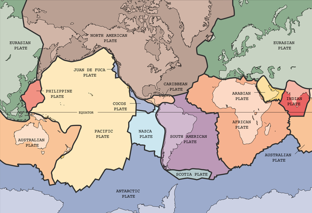
Tectonic plates of the Earth. From wikipedia.en, retrieved from USGS site: http://pubs.usgs.gov/publications/text/slabs.html Original Image URL: [3] Listed contact: mailto:jmwatson@usgs.gov
|
| Ọjọ́ọdún | 30 Oṣù Kejìlá 2004 (upload date) |
| Orísun | [4] |
| Olùdá |
|
| Àwọn àtẹ̀jáde míràn |
Derivative works of this file: |
.svg)
![[3]](https://pubs.usgs.gov/publications/graphics/Fig1.gif)
.png)
This image was selected as picture of the day on Wikimedia Commons for 20 February 2005. It was captioned as follows: English: Map of the tectonic plates of the Earth Other languages:
Čeština: Mapa tektonických desek Země Deutsch: Karte der tektonischen Platten der Erde English: Map of the tectonic plates of the Earth Español: Mapa de las placas tectónicas de la Tierra. Esperanto: Mapo de la tectonic teleroj de la tero Français : Carte des plaques tectoniques terrestres. Italiano: Mappa delle placche tettoniche della terra Lëtzebuergesch: Kaart vun den tektonesche Placke vun der Äerd. Nederlands: Kaart met de tektonische platen van de aarde Norsk bokmål: Kart over verdas tektoniske plater. Português: Mapa das placas tectônicas da Terra Suomi: Maapallon tektoniset laatat. Svenska: Karta över de tektoniska plattor som täcker jordens yta. Български: Карта на тектоничните плочи на Земята Русский: Карта тектонических плит 日本語: 地球の表面を覆うプレート 中文: 地球板块结构图 |

|
File:Plates tect2 en.svg is a vector version of this file. It should be used in place of this PNG file when not inferior.
File:Tectonic plates.png → File:Plates tect2 en.svg
For more information, see Help:SVG. |
 |
Ìwé àṣẹ
This image is in the public domain in the United States because it only contains materials that originally came from the United States Geological Survey, an agency of the United States Department of the Interior. For more information, see the official USGS copyright policy.
|
Ìtàn fáìlì
Ẹ kan kliki lórí ọjọ́ọdún/àkókò kan láti wo fáìlì ọ̀ún bó ṣe hàn ní àkókò na.
| Ọjọ́ọdún/Àkókò | Àwòrán kékeré | Àwọn ìwọ̀n | Oníṣe | Àríwí | |
|---|---|---|---|---|---|
| lọ́wọ́ | 03:25, 4 Oṣù Kejì 2022 | | 6,740 × 4,600 (4.45 MB) | TSamuel | Restored previous version, but losslessly recompressed |
| 20:58, 26 Oṣù Kẹ̀wá 2005 |  | 4,150 × 2,832 (3.05 MB) | Dbenbenn | thumbnail, since MediaWiki now refuses to scale PNG images that are more than 12.5 megapixels | |
| 09:40, 26 Oṣù Kẹ̀wá 2005 |  | 6,740 × 4,600 (4.96 MB) | Ævar Arnfjörð Bjarmason | Larger version from Image:Tectonic plates large.png | |
| 22:46, 30 Oṣù Kejìlá 2004 |  | 634 × 433 (52 KB) | Muriel Gottrop~commonswiki | Tectonic plates |
Ìlò fáìlì
Kò sí ojúewé tó únlo fáìlì yìí.
Ìlò fáìlì káàkiri
Àwọn wiki míràn wọ̀nyí lo fáìlì yìí:
- Ìlò ní ang.wikipedia.org
- Ìlò ní be-tarask.wikipedia.org
- Ìlò ní be.wikipedia.org
- Ìlò ní cv.wikipedia.org
- Ìlò ní en.wikipedia.org
- Ìlò ní en.wikibooks.org
- Ìlò ní fa.wikipedia.org
- Ìlò ní hr.wikipedia.org
- Ìlò ní hy.wikipedia.org
- Ìlò ní hyw.wikipedia.org
- Ìlò ní ia.wikipedia.org
- Ìlò ní is.wikibooks.org
- Ìlò ní ko.wikipedia.org
- Ìlò ní lt.wikipedia.org
- Ìlò ní mn.wikipedia.org
- Ìlò ní pl.wikipedia.org
- Ìlò ní pt.wikipedia.org
- Ìlò ní sl.wikipedia.org
- Ìlò ní sv.wikibooks.org
- Ìlò ní vi.wikipedia.org
- Ìlò ní www.wikidata.org