Fáìlì:USSR Republics Numbered Alphabetically.png
Fáìlì àtìbẹ̀rẹ̀ (1,356 × 928 pixel, ìtóbi faili: 80 KB, irú MIME: image/png)
|
|
Fáìlì yìí wá láti Wikimedia Commons. Àròyé láti ojúewé ìjúwe rẹ̀ níbẹ̀ nìyí nísàlẹ̀. |

|
File:USSR Republics numbered by alphabet.svg is a vector version of this file. It should be used in place of this PNG file when not inferior.
File:USSR Republics Numbered Alphabetically.png → File:USSR Republics numbered by alphabet.svg
For more information, see Help:SVG. |
 |
Àkótán
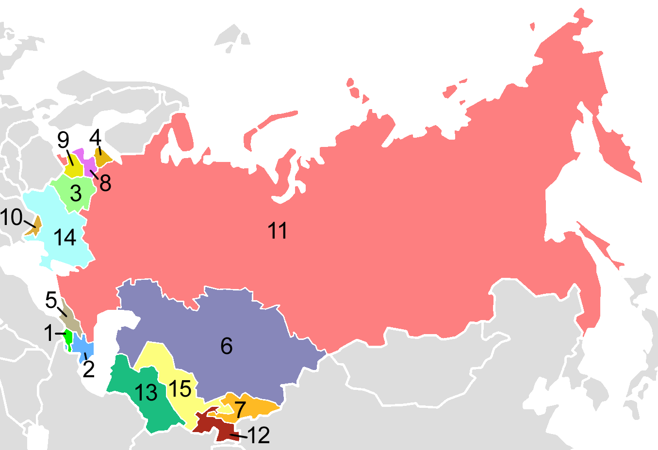
USSR Republics, numbered alphabetically.
Post-Soviet states in English alphabetical order:
| 1. | Armenia |
| 2. | Azerbaijan |
| 3. | Belarus |
| 4. | Estonia |
| 5. | Georgia |
| 6. | Kazakhstan |
| 7. | Kyrgyzstan |
| 8. | Latvia |
| 9. | Lithuania |
| 10. | Moldova |
| 11. | Russia |
| 12. | Tajikistan |
| 13. | Turkmenistan |
| 14. | Ukraine |
| 15. | Uzbekistan |
Map created by en:User:Aris_Katsaris, based on Image:Soviet Union Map.png in mimicry of the concept of fr:Image:USSR_Republics_Numbered_Alphabetically.png.
Ìwé àṣẹ
| This map is ineligible for copyright and therefore in the public domain, because it consists entirely of information that is common property and contains no original authorship. For more information, see Commons:Threshold of originality § Maps.
|
Derivative works
Derivative works of this file: Soviet Socialist Republics numbered by the Soviet constitution.png
| Annotations | This image is annotated: View the annotations at Commons |
Ìtàn fáìlì
Ẹ kan kliki lórí ọjọ́ọdún/àkókò kan láti wo fáìlì ọ̀ún bó ṣe hàn ní àkókò na.
| Ọjọ́ọdún/Àkókò | Àwòrán kékeré | Àwọn ìwọ̀n | Oníṣe | Àríwí | |
|---|---|---|---|---|---|
| lọ́wọ́ | 03:40, 3 Oṣù Kẹjọ 2009 | | 1,356 × 928 (80 KB) | Hoshie | Added border for N. Ireland; spilit Germany so that this map dates from 1988-89 |
| 21:06, 10 Oṣù Kẹ̀wá 2008 |  | 1,356 × 928 (52 KB) | Milosevo | {{Information |Description= |Source= |Date= |Author= |Permission= |other_versions= }} | |
| 03:38, 15 Oṣù Kẹrin 2005 |  | 1,356 × 928 (46 KB) | Aris Katsaris | USSR Republics, numbered alphabetically. Created by User:Aris Katsaris, based on Image:Soviet Union Map.png, in mimicry of the concept of en:Image:Soviet republics.jpg. {{GFDL}} Category:Political divisions of the Soviet Union [[Categor |
Ìlò fáìlì
Kò sí ojúewé tó únlo fáìlì yìí.
Ìlò fáìlì káàkiri
Àwọn wiki míràn wọ̀nyí lo fáìlì yìí:
- Ìlò ní af.wikipedia.org
- Ìlò ní als.wikipedia.org
- Ìlò ní ar.wikipedia.org
- Ìlò ní ast.wikipedia.org
- Ìlò ní avk.wikipedia.org
- Ìlò ní azb.wikipedia.org
- Ìlò ní ban.wikipedia.org
- Ìlò ní be-tarask.wikipedia.org
- Ìlò ní bg.wikipedia.org
- Ìlò ní br.wikipedia.org
- Ìlò ní bs.wikipedia.org
- Ìlò ní ca.wikipedia.org
- Ìlò ní ckb.wikipedia.org
- Ìlò ní cs.wikipedia.org
- Ìlò ní cv.wikipedia.org
- Ìlò ní cy.wikipedia.org
- Ìlò ní da.wikipedia.org
- Sovjetunionen
- Bruger:Rasmus81/Sandkasse2
- Jødiske autonome oblast
- Russiske SFSR
- Sovjetrepublik
- Karelsk-finske SSR
- Lettiske SSR
- Aserbajdsjanske SSR
- Skabelon:Navboks Sovjetunionens administrative inddeling
- Hviderussiske SSR
- Ukrainske SSR
- Karelske ASSR
- Litauiske SSR
- Estiske SSR
- Autonome Socialistiske Sovjetrepublikker i Sovjetunionen
- SNG ved OL
- Tadsjikiske SSR
- Georgiske SSR
Ìfihàn ìlò míràn púpọ̀ fún fálì yìí.