Fáìlì:Waterloo campaign map.png

Ìtóbi ìkọ́yẹ̀wò yìí: 527 × 599 pixels. Àwọn ìgbéhàn míràn: 211 × 240 pixels | 422 × 480 pixels.
Fáìlì àtìbẹ̀rẹ̀ (800 × 910 pixel, ìtóbi faili: 43 KB, irú MIME: image/png)
|
|
Fáìlì yìí wá láti Wikimedia Commons. Àròyé láti ojúewé ìjúwe rẹ̀ níbẹ̀ nìyí nísàlẹ̀. |

|
File:Waterloo Campaign map-alt3.svg is a vector version of this file. It should be used in place of this PNG file.
File:Waterloo campaign map.png → File:Waterloo Campaign map-alt3.svg
For more information, see Help:SVG. |
 |
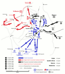
English: Map of force movements and major engagements during the Waterloo Campaign, June 15-18, 1815. Based on a map from The Oxford History of the British Army, 1994.
Español: Mapa táctico de la Batalla de Waterloo, basado en un mapa del libro The Oxford History of the British Army, 1994.
中文:滑鐵盧戰役中,1815年6月15-18日,軍力運動與主要交戰示意圖。 根據1994年The Oxford History of the British Army的一幅地圖。
| This work has been released into the public domain by its author, Gsl. This applies worldwide. In some countries this may not be legally possible; if so: |
Ìtàn fáìlì
Ẹ kan kliki lórí ọjọ́ọdún/àkókò kan láti wo fáìlì ọ̀ún bó ṣe hàn ní àkókò na.
| Ọjọ́ọdún/Àkókò | Àwòrán kékeré | Àwọn ìwọ̀n | Oníṣe | Àríwí | |
|---|---|---|---|---|---|
| lọ́wọ́ | 09:21, 10 Oṣù Ṣẹ̀rẹ́ 2006 | | 800 × 910 (43 KB) | Gsl~commonswiki | 3rd version: reinstated french move ligny -> qb, prussian iv corps movement to wavre |
| 09:20, 10 Oṣù Ṣẹ̀rẹ́ 2006 |  | 800 × 910 (35 KB) | Gsl~commonswiki | 2nd version, fixed errors, add scale, expand key, prussian colour scheme | |
| 09:19, 10 Oṣù Ṣẹ̀rẹ́ 2006 |  | 800 × 892 (82 KB) | Gsl~commonswiki | original version from en.wikipedia.org | |
| 15:00, 14 Oṣù Òwéwe 2005 |  | 800 × 910 (43 KB) | Mattes | new | |
| 16:46, 21 Oṣù Agẹmọ 2005 |  | 800 × 910 (43 KB) | Dbenbenn | from w:Image:Waterloo campaign map.png by w:User:Gsl, PD |
Ìlò fáìlì
Kò sí ojúewé tó únlo fáìlì yìí.
Ìlò fáìlì káàkiri
Àwọn wiki míràn wọ̀nyí lo fáìlì yìí:
- Ìlò ní ast.wikipedia.org
- Ìlò ní en.wikipedia.org
- Ìlò ní eo.wikipedia.org
- Ìlò ní eo.wikiquote.org
- Ìlò ní es.wikipedia.org
- Ìlò ní eu.wikipedia.org
- Ìlò ní fi.wikipedia.org
- Ìlò ní gl.wikipedia.org
- Ìlò ní he.wikipedia.org
- Ìlò ní hi.wikipedia.org
- Ìlò ní hu.wikipedia.org
- Ìlò ní id.wikipedia.org
- Ìlò ní it.wikipedia.org
- Ìlò ní ja.wikipedia.org
- Ìlò ní ja.wikibooks.org
- Ìlò ní ko.wikipedia.org
- Ìlò ní lmo.wikipedia.org
- Ìlò ní nl.wikipedia.org
- Ìlò ní pl.wikipedia.org
- Ìlò ní pt.wikipedia.org
- Ìlò ní ro.wikipedia.org
- Ìlò ní ru.wikipedia.org
- Ìlò ní sh.wikipedia.org
- Ìlò ní sr.wikipedia.org
- Ìlò ní www.wikidata.org