Fáìlì:Ceuta en.png

Ìtóbi ìkọ́yẹ̀wò yìí: 800 × 417 pixels. Àwọn ìgbéhàn míràn: 320 × 167 pixels | 640 × 333 pixels | 1,024 × 533 pixels | 1,280 × 667 pixels | 1,993 × 1,038 pixels.
Fáìlì àtìbẹ̀rẹ̀ (1,993 × 1,038 pixel, ìtóbi faili: 457 KB, irú MIME: image/png)
|
|
Fáìlì yìí wá láti Wikimedia Commons. Àròyé láti ojúewé ìjúwe rẹ̀ níbẹ̀ nìyí nísàlẹ̀. |

|
This image could be re-created using vector graphics as an SVG file. This has several advantages; see Commons:Media for cleanup for more information. If an SVG form of this image is available, please upload it and afterwards replace this template with
{{vector version available|new image name}}.
It is recommended to name the SVG file “Ceuta en.svg”—then the template Vector version available (or Vva) does not need the new image name parameter. |
Àkótán
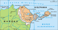
English: Map of Ceuta, Spain. The original image is Image:Ceuta.png
Author
Author Aotearoa, translated by Hoshie
.png)
Ìwé àṣẹ
Èmi gangan, tó jẹ́ pé èmi ni mo ni ẹ̀tọ́àwòkọ iṣẹ́ yìí, fara mọ́ ọ láti tẹ̀ẹ́jáde lábẹ́ ìwé-àṣẹ ìsàlẹ̀ yìí:

|
Ìyọ̀nda wà láti ṣe àwòkọ, láti pínkàkiri àti/tàbí ṣ'àtúnse ìwé yìí l'ábẹ́ àwọn ọ̀rọ̀ àdéhùn GNU Free Documentation License, Version 1.2 tàbí ìtẹ̀jáde ọjọ́ọwájú lát'ọwọ́ Free Software Foundation; láìsí àwọn Ẹsẹ Aláìyàtọ̀, láìsí àwọn Ọ̀rọ̀-ìwé Níwájú, àti láìsí Ọ̀rọ̀-ìwé Lẹ́yìn. Àwòkọ ìwé àṣẹ náà jẹ́ sísopọ̀ mọ́ abala tí àkọlé rẹ̀ jẹ́ GNU Free Documentation License. |
| Fáìlì yìí wà lábẹ́ ìwé àṣẹ Creative Commons Ìdálórúkọ-Share Alike 3.0 Aláìkówọlé. | ||
| ||
| Àlẹ̀mọ́ ìwé àṣẹ yìí jẹ́ lílẹ̀mọ́ fáìlí yìí gẹ́gẹ́ bíi apá GFDL ìṣọdọ̀tun ìwé àṣẹ. |
See also
-
 Spanish captions.
 -
 Polish captions.


Ìtàn fáìlì
Ẹ kan kliki lórí ọjọ́ọdún/àkókò kan láti wo fáìlì ọ̀ún bó ṣe hàn ní àkókò na.
| Ọjọ́ọdún/Àkókò | Àwòrán kékeré | Àwọn ìwọ̀n | Oníṣe | Àríwí | |
|---|---|---|---|---|---|
| lọ́wọ́ | 12:53, 16 Oṣù Keje 2010 | | 1,993 × 1,038 (457 KB) | Aotearoa | Reverted to version as of 04:21, 18 December 2006 |
| 06:21, 4 Oṣù Keje 2010 |  | 1,993 × 1,038 (383 KB) | Omar-Toons | better map, adapted from the Spanish npov image. | |
| 05:58, 4 Oṣù Keje 2010 |  | 1,993 × 1,038 (381 KB) | Omar-Toons | npov: Perejil is recognised as a neutral territory | |
| 04:21, 18 Oṣù Kejìlá 2006 |  | 1,993 × 1,038 (457 KB) | Hoshie | {{en|Map of Ceuta and the Perejil Island, in Spain. The original image is Image:Ceuta.png}} == Author == Author Aotearoa, translated by ~~~ == License== {{self|GFDL}} *** Category:Maps of Spain |
Ìlò fáìlì
Ojúewé kan yìí únlo fáìlì yí:
Ìlò fáìlì káàkiri
Àwọn wiki míràn wọ̀nyí lo fáìlì yìí:
- Ìlò ní ar.wikipedia.org
- Ìlò ní bn.wikipedia.org
- Ìlò ní ca.wikipedia.org
- Ìlò ní en.wikipedia.org
- Ìlò ní he.wikipedia.org
- Ìlò ní hr.wikipedia.org
- Ìlò ní incubator.wikimedia.org
- Ìlò ní ja.wikipedia.org
- Ìlò ní mt.wikipedia.org
- Ìlò ní pt.wikipedia.org
- Ìlò ní uk.wikipedia.org