Fort-de-France
Fort-de-France ni oluilu Martinique tii se ipinpa okere Fransi ni Karibeani ni Ariwa Amerika.
|
Fort-de-France | |

| |
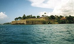
| Fort Saint Louis | |

| |
| Location of the commune (in red) within Martinique | |
| Administration | |
|---|---|
| Country | France |
| Overseas region and department | Martinique |
| Arrondissement | Fort-de-France |
| Intercommunality | Centre de la Martinique |
| Mayor | Serge Letchimy (2008–2014) |
| Statistics | |
| Elevation | 0–1,070 m (0–3,510 ft) |
| Land area1 | 44.21 km2 (17.07 sq mi) |
| Population2 | 91,249 (2007) |
| - Density | 2,064/km2 (5,350/sq mi) |
| Time zone | UTC-4 |
| INSEE/Postal code | 97209/ 97200 |
| 1 French Land Register data, which excludes lakes, ponds, glaciers > 1 km² (0.386 sq mi or 247 acres) and river estuaries. | |
| 2 Population without double counting: residents of multiple communes (e.g., students and military personnel) only counted once. | |
Coordinates: 14°36′00″N 61°05′00″W / 14.6°N 61.08334°W


|
Àyọkà yìí tàbí apá rẹ̀ únfẹ́ àtúnṣe sí. Ẹ le fẹ̀ jù báyìí lọ tàbí kí ẹ ṣàtúnṣe rẹ̀ lọ́nà tí yíò mu kúnrẹ́rẹ́. Ẹ ran Wikipedia lọ́wọ́ láti fẹ̀ẹ́ jù báyìí lọ. |