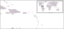
Montserrat
Montserrat (pípè /mɒntsəˈræt/) is a British overseas territory located in the Leeward Islands, part of the chain of islands called the Lesser Antilles in the Caribbean Sea. It measures approximately 16 km (10 miles) long and 11 km (7 miles) wide, giving 40 kilometres (25 mi) of coastline.[3]
Montserrat
| |
|---|---|
Orin ìyìn: "God Save the Queen" | |
 | |
| Olùìlú | Plymouth (de jure) 1 Brades (de facto) |
| Àwọn èdè ìṣẹ́ọba | English |
| Àwọn ẹ̀yà ènìyàn | West African, Mulatto Creoles, British, Irish[1] |
| Ìjọba | British Overseas Territory |
• Queen | Elizabeth II |
• Governor | Peter Andrew Waterworth |
| Reuben Meade | |
| British overseas territory | |
• British control established | 1632 |
| Ìtóbi | |
• Total | 102 km2 (39 sq mi) (219th) |
• Omi (%) | negligible |
| Alábùgbé | |
• July 2006 estimate | 4,655[2] (216th) |
• Ìdìmọ́ra | {{convert/{{{d}}}|114||/km2|1|s=|r={{{r}}}
|u=/sq mi |n=per square mile |h=per-square-mile |l=per square mile |o=/sqkm |t=square mile |b=(15625/40468564224) |j=-6.41329777-0}} (153rd) |
| GDP (PPP) | 2002 estimate |
• Total | $99 million (not ranked) |
• Per capita | $3,400 (not ranked) |
| HDI | n Error: Invalid HDI value · n/a |
| Owóníná | East Caribbean dollar (XCD) |
| Ibi àkókò | UTC-4 |
| Àmì tẹlifóònù | +1-664 |
| ISO 3166 code | MS |
| Internet TLD | .ms |


|
Àyọkà yìí tàbí apá rẹ̀ únfẹ́ àtúnṣe sí. Ẹ le fẹ̀ jù báyìí lọ tàbí kí ẹ ṣàtúnṣe rẹ̀ lọ́nà tí yíò mu kúnrẹ́rẹ́. Ẹ ran Wikipedia lọ́wọ́ láti fẹ̀ẹ́ jù báyìí lọ. |
Itokasi
àtúnṣe- ↑ History/Irish Heritage
- ↑ http://web.archive.org/web/20100223014047/http://www.fco.gov.uk/en/travel-and-living-abroad/travel-advice-by-country/country-profile/north-central-america/montserrat
- ↑ Montserrat Archived 2020-04-24 at the Wayback Machine. CIA World Factbook, 19 September 2006. Retrieved 1 October 2006.

